
Brian E. Mennecke
Decision Science Department,
School of Business, East Carolina University, NC 27858, USA
dcbrian@ecuvax.cis.ecu.edu
http://mennecke.business.ecu.edu/
Contents
When you consider the location of a facility or of a destination (e.g.,
the restaurant at which you will eat your lunch), how do you typically
think about that location? In most cases, people consider the location
in relation to the features of relevance that are in proximity to that
site. Now, consider the way in which the typical decision support system
(DSS) is used for decision making. Certainly a number of relevant criteria
are considered in the models and analyses that are processed using these
systems. However, in the majority of cases, relevant spatial criteria are
inadequately represented in these systems and, for that matter, in most
of the information systems that are typically used by organizations and
studied by organizational researchers. Of course, spatially enabled decision
support technologies such as geographic information systems (GIS) are available
and can be used by decision makers to capitalize on the wealth of information
that is present in spatial data.
Although GIS have been used
for several years in the natural resources, forestry, and environmental
industries, only recently have they begun to be used for a broader array
of business and management functions such as logistics, site and facilities
management, marketing, decision making, and planning. The fact that businesses
and public sector organizations have begun to use GIS is not surprising,
particularly given the fact that much of the data that organizations typically
use include significant spatial components (estimates range between 50%
and 85%). Because of these and other reasons, an increasing number of businesses
have begun to make substantial use of GIS for a variety of routine decision
support and analysis applications (e.g., market and demographic analyses).
The size of the GIS market -- estimated at $1.1 billion in 1995 (Daratech1995)
- highlights the importance of this technology as a decision support tool.
In spite of the importance
of this technology, too little research has been done to understand the
role of this technology in business. More than a decade ago business school
researchers had recognized the promise and importance of mapping (see
Ives 1982; Takeuchi and Schmidt 1980). Nevertheless, few business scholars
have chosen to follow this stream with the result that researchers from
other academic disciplines such as geography and computer science have
performed the bulk of the research on GIS applications and functionality.
Researchers in disciplines such as information systems, marketing, real
estate, and management can add a great deal to the existing GIS research
literature by applying theories, frameworks, applications, and perspectives
from their respective fields of study.
Given this, the purpose
of this paper is to provide an introduction to GIS in business and to propose
and discuss a research framework for those seeking to study the role of
GIS in business analysis, decision making, and use. To accomplish this,
I first provide an overview of GIS technology. Following this, a framework
for GIS applications in business is proposed and examples of representative
applications are cited and discussed. Next, prospective research activities
for scholars from the business community are presented. The paper concludes
with a summary and conclusions.
2. Geographic information systems for decision support: a definition
Fundamentally, a GIS is a tool for linking attribute databases with
digital maps. However, GIS is really much more than this simple definition
would imply. In fact, several definitions of GIS have been proposed, each
of which suggest that GIS is much more than merely an electronic mapping
tool (see Table 1). Something that is common to most
of these definitions is the notion that GIS not only provide users with
an array of tools for managing and linking attribute and spatial data,
but they also provide users with advanced modeling functions, tools for
design and planning, and advanced imaging capabilities. While many of these
capabilities also exist in other types of systems, such as visualization
and virtual reality systems, GIS are unique because of their emphasis on
providing users with a representation of objects in a cartographically-accurate
spatial system and on supporting analysis and decision making.
Although data capture,
manipulation, and management are important functions of GIS, most GIS are
eventually used to support data analysis and decision making. The literature
in the management information systems field is rich with descriptions of
various decision support technologies that can be applied to GIS. For example,
Sprague
(1980),
Turban
(1995), and others have provided useful frameworks for understanding the
nature and role of decision support technologies. In particular, the framework
proposed by Turban (1995) is quite useful for defining a practical framework
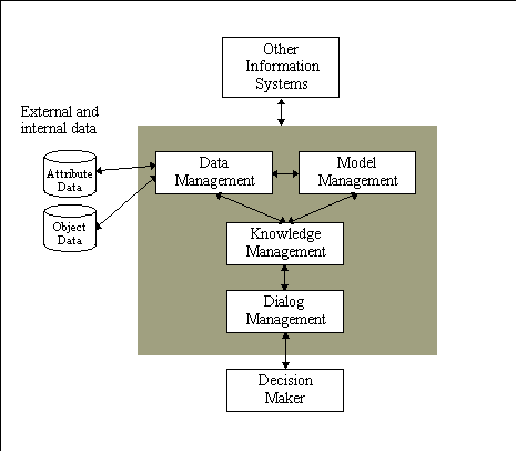
for considering GIS (Figure 1). Using such a framework
it becomes clear that GIS include all of the features that are in a DSS;
however, they also include several other components (1).
For example, a DSS includes various subsystems including data management,
model management, knowledge management subsystem, and dialog management
subsystems. A GIS includes similar subsystems, albeit subsystems which
are spatially enabled. For example, a typical aspatial DSS will include
a data management subsystem designed to manage textual or, in some cases,
object-oriented data. A GIS must not only be able to manage these types
of data, but also manage and integrate spatial data (e.g., data which include
cartographic coordinates).
| Table 1 Definitions of a GIS | |
|
|
|
| Dueker (1979; p. 106) | "a special case of information systems where the database consists of observations on spatially distributed features, activities, or events, which are definable in space as points, lines or areas. A GIS manipulates data about these points, lines, and areas to retrieve data for ad hoc queries and analyses." |
| Ozemoy, Smith, and
Sicherman
(1981; p. 92) |
"an automated set of functions that provides professionals with advanced capabilities for the storage, retrieval, manipulation, and display of geographically located data." |
| Burrough (1986; p. 6) | "a powerful set of tools for collecting, storing, retrieving, at will, transforming and displaying spatial data from the real world." |
| Devine and Field (1986; p. 18) | "a form of MIS [Management Information System] that allows map display of the general information." |
| Department of the Environment
(1987, p. 132) |
"a system for capturing, storing, checking, manipulating, analysing, and displaying data which are spatially referenced to the Earth." |
| Smith, Menon, Starr,
and Estes
(1987; p. 13) |
"a database system in which most of the data are spatially indexed, and upon which a set of procedures operated in order to answer queries about spatial entities in the database." |
| Cowen (1988; p. 1554) | "a decision support system involving the integration of spatially referenced data in a problem-solving environment." |
| Aronoff (1989, p. 39) | "any manual or computer based set of procedures used to store and manipulate geographically referenced data." |
| Carter (1989; p. 3) | "an institutional entity, reflecting an organizational structure that integrates technology with a database, expertise, and continuing financial support over time." |
| Koshkariov, Tikunov,
and Trofimov
(1989; p. 259) |
"a system with advanced geo-modeling capabilities." |
| Parker (1989; p. 1547) | "an information technology which stores, analyses, and displays both spatial and non-spatial data." |
Similarly, a GIS must have a
model manager that includes the typical functions, models, and statistical
operations present in a DSS, but it also must provide the user with spatial
models and capabilities that can be used to perform spatial modeling and
spatial statistical calculations. To help the user manage the complexity
involved in integrating these models with attribute and spatial data, several
developers have incorporated knowledge management facilities within GIS
(see Leung and Leung 1993a, 1993b; Skidmore at.
al. 1991; Smith and Yiang 1991; Wu et al. 1988). Finally,
a GIS has a dialog management subsystem that enables users to query and
output attribute data, but it also includes spatial query and output capabilities.
|

|
Business requirements for information systems are as diverse as the
many types of businesses that exist. Nevertheless, many core business functions
are similar to functions performed by the public sector organizations that
have used geographic information technologies for the last three decades.
For example, Landis (1993) suggests that most
organizations use information systems for one or more of five applications:
transaction processing, operations, inventory control, planning and decision
making, and internal management and control. GIS can be used for these
functions because this technology possesses capabilities that are common
to traditional aspatial information systems. In addition, GIS also possess
characteristics that provide them with capabilities that are not present
in other information systems.
These relationships are
portrayed in a conceptual model of GIS (see Figure 3)
that portrays four GIS functions and related applications. The four functions
are derived from four unique activities for which GIS can be used to address
the needs of business. The GIS functions are spatial visualization, database
management, decision modeling, and design and planning. Spatial imaging
refers
to the fundamental GIS capability of representing displays of data and
information within a spatially-defined coordinate system. The
database
management function represents the capability of GIS to store, manipulate,
and provide access to data. The decision modeling function represents
the capability of GIS to be used to provide support for analysis and decision
making. Finally, the design and planning function represents the
capability of GIS to be used to create, design, and plan. In addition to
these specific functions, the model also represents several specific GIS
applications toward which these functions can be applied: spatial data
collection and automated mapping, facility management, market analysis,
transportation, logistics, strategic planning, decision making, design
and engineering. The remainder of this section consists of a discussion
of these business applications and how they relate to this model.
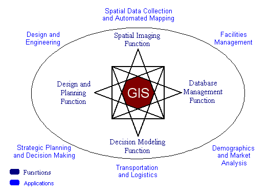
Figure 3
GIS Functions and Applications
3.1. Spatial Data Collection and Automated Mapping
One of the first applications of geographic information technologies
was that of capturing spatial data to automatically generate maps (Coppock
and Rhind 1991). Software designed to support automated mapping (AM)
represents a powerful tool for business applications because it provides
managers with the ability to generate spatial data in-house. Nevertheless,
data capture can be one of the more problematic areas for GIS users. For
instance, data conversion costs can easily exceed twenty percent of the
cost of a GIS implementation (Smith and Tomlinson 1992) and data accuracy
is often a significant problem (Chrisman 1991; Goodchild
1992). Errors arise for several reasons including problems associated
with defining positional accuracy (e.g., is the object where the map says
it is?), attribute accuracy (e.g., is the object defined and classified
correctly?), and completeness (e.g., are all the relevant objects included
in our map?) (Chrisman 1991). One of the biggest
problems with map making is the fact that often the definition of an object
depends both on the user's purpose for the map (i.e., what objects are
to be coded?) and interpretive issues (e.g., is this a tree or a bush?)
(Goodchild 1992). Finally, the training of personnel
also represents an important constraint in an organization's ability to
capture or create maps. Generally speaking, map production requires knowledge
of cartographic, database management, and land surveying principles, principles
that many or most business people do not possess (Unwin
1991). This has often forced the business user of GIS to rely on either
commercially generated or government generated data. Although these data
are often adequate for many purposes, the scale and accuracy of these maps
may not be useful for many business functions (e.g., a large scale map
showing the precise location of facilities or equipment in a specific area
would likely not be readily available from a vender or consultant).
Although error propagation
and training continue as problems, potential opportunities for businesses
to make use of AM tools still exist. Remote sensing and global positioning
systems (GPS) allow more accurate map production by removing the paper
map as a data source (Goodchild 1992). These
advances, combined with improved interpretive tools such as pattern recognition
software, mean that a greater number of end users will be able to integrate
AM into their routine business activities.
For example, Electric utilities
probably lead all businesses in their use of automated mapping, having
begun early in the 1970s to use commercial GIS technology. Utilities like
South Carolina Electric and Gas, B.C. Hydro, Alabama Power, Wisconsin Electric
Power, and Southern California Edison use GIS technology to perform automated
mapping (2).
Northern States Power, which provides electric and gas services across
five Midwestern states, uses GIS integrated with other corporate systems
for automated mapping, managing facilities data and customer records, and
other activities such as order processing and network analysis.
Companies in the petroleum
business have some of the largest automated mapping operations in the world.
For example, Chevron, Shell Oil, Texaco, and Union Pacific Resources have
adopted GIS and digital mapping for supporting their operational and exploratory
activities (e.g., managing well locations, lease information, seismic information
and other kinds of data). Similarly, Petroleum Information, a firm which
provides mapped information for the oil industry, has more than two million
well locations that it has captured and stored in its database. Other natural
resource industries likewise use GIS for automated mapping. These include
the mining industry, represented by companies like Independence Mining,
and firms working with groundwater and environmental management, such as
Ground Water Systems, Inc.
Automated mapping is increasingly
being used for other business activities such as data sources for marketing
systems. For example, GPS is being used to collect data that are used to
select the location of and content for outdoor billboards. Companies like
Outdoor Technologies in Austin, Texas, market a database of billboard locations.
Using GPS, the billboard locations and their attributes are recorded and
downloaded for use in a GIS. These data, combined with data about street
and highway traffic patterns, can be used to perform accurate demographic
analysis of neighborhoods surrounding the billboards.
As with many technologies,
automated mapping applications have begun to appear on the Internet. Many
of these tools are designed for entertainment and other casual applications (3).
However, a number of organizations have used automated map making for practical
applications. For example, InfoNow, a company based in Aurora Colorado,
has developed an on line service called FindNow which enables a company
to provide customers with information and maps showing the locations of
facilities, service centers, or retail locations. Visa Plus has used this
service to develop an ATM Locator Service that allows a customer to locate
the three nearest ATM machines to a specified street address or intersection (4).
GIS have been used extensively for facilities management (FM) in the
public sector and have great potential for use in the private sector as
well. Utility firms, for example, represent one of the largest private-sector
GIS end-user groups. In her review of utility applications of GIS technology,
Rector
(1993) notes that GIS fulfills "an ever-increasing demand for information
pertaining to the location, condition, and performance of the utilities'
infrastructure" (p. 193). These information requirements are not limited
to utilities since many organizations must manage and control facilities
such as manufacturing plants, distribution centers, retail outlets, and
other components of the organization's portfolio of physical assets. FM
provides managers with a powerful tool for supporting real-time monitoring
of facilities and is routinely used for emergency management, security,
and other applications.
The key functions of GIS
used in FM are the spatial visualization and database management functions.
In other words, most FM applications use historical or transaction (real-time)
data to manage or monitor facilities. They also rely heavily on the imaging
capabilities of GIS to represent the spatial arrangement of data elements.
The AM function of GIS are often combined with FM functions to provide
organizations with a system for generating, managing, and utilizing maps
and other spatial data that can be used to manage an organization's physical
plant (i.e., AM/FM Systems).
Utilities, as mentioned
earlier, use GIS for automated mapping; they also make extensive use of
GIS for facilities management. These utilities include those mentioned
earlier, as well as Boston Edison, Bell South, Consolidated Natural Gas,
Kentucky Utilities, and many others (see Montgomery
1995). For example, Pennsylvania Power and Light has located more than
two million utility poles using geographic information technology. Boston
Gas has created an Automated Mains Management System project which integrates
thousands of maps of their distribution system and other information such
as leak histories, soil conditions, and construction activity. Wisconsin
Electric Power Company is providing a Work Management System, Electronic
Map Access, and a Distribution Dispatch Operating System using GIS technology
to service its customers.
Besides utilities, other
types of companies also use GIS to manage their facilities. Conrail, a
division of CSX which operates a rail freight network in 14 northeastern
and Midwestern states and the Province of Quebec, is integrating GIS with
its other information technologies and creating an enterprise-wide information
system (Mennecke
et al. in press; Vaidya and
Lang,1994). Likewise, billboard companies like Gateway Outdoor Advertising
(Somerset, NJ) and Patrick Media Group (Chicago, Illinois) maintain information
about billboards, including photographs and regional demographic information,
to help manage and promote each billboard (Battista
1994).
3.3. Demographic and Market Analysis
Marketing represents the business application for GIS that has enjoyed
the most growth in recent years. Many factors have driven this trend, however,
both the increasingly competitive U.S. and international marketplaces and
the widespread availability of low cost government-generated data (e.g.,
census data) have undoubtedly contributed to this phenomenon. Furthermore,
many organizations have been forced to refocus products and services into
'niche' markets that require more detailed information about customers
(McKenna 1995). The primary function of market
analysis is to understand the marketplace; in other words, "market analysis
means using customer information to estimate the size and character of
a market" (Francese and Piirto 1990, p. 105).
GIS is a powerful market analysis tool because it provides a platform for
representing the spatial relationship between the components of the market;
that is, the customers, suppliers, and competitors. This has become all
the more important as greater competition has forced many firms to find
new ways to manage their relationships with customers. Strategies such
as target marketing, micro-marketing, and relationship marketing all require
that firms capture and maintain detailed information about their customers
(Webster 1994). The ultimate goal of all of these
efforts is usually to bring a product or service to someone, somewhere;
thus, an understanding of the geodemographic characteristics of the firm's
customers is critical to a successful marketing strategy.
While all four of the GIS
functions shown in Figure 1 are used in market analysis
to one degree or another, the key GIS functions used are the database management
and decision modeling functions. In most cases, market analysis applications
use historical or transaction (real-time) data in combination with decision
modeling and support tools to analyze the organization's marketing environment.
Furthermore, GIS is a powerful tool in market analyses because it also
provides a way to bring together data from multiple sources and link them
based on spatial attributes. This often involves a process of layering
different types of data on the same map projection so that the decision
maker can identify and visualize how data intersect and interact. Thus,
GIS is a useful and unique query tool for accessing and displaying components
of a database based on the data's spatial characteristics.
A number of organizations
have successfully applied GIS to their marketing intelligence and analysis
needs. For example, fast food restaurants and other food service firms
have been one of the most prominent business users of geographic technologies.
Firms such as Arby's, Burger King, The Olive Garden, Popeyes, Red Lobster,
and others use GIS for market analysis, franchisee selection and placement,
site location analysis, and demographic profiling (Battista
1995). MacDonald's has used geographic technologies for a number of
years and is recognized as an industry leader in the use of geographic
information technologies because of its progressive use of GIS for a wide
variety of marketing and operational applications.
Many firms apply GIS in
market-based site selection and market analyses. Val-Pak Direct Marketing
Services, Inc., the nation's largest local cooperative direct mail advertising
company, uses GIS to micromarket, analyze trade areas, and manage territories
(Wendelken 1994). Texaco uses GIS to explore
markets for siting new Texaco stations and for enhancing existing facilities.
Included in these activities are demographic analyses of neighborhoods
and competitor locations to identify likely locations for new stations
and the appropriate advertising and product mix for existing stores (Lang
1996b).
Levi Strauss and Co., a
leader in the casual apparel market, uses GIS for a broad spectrum of marketing
applications. For example, they use geographic technologies to customize
their regional advertising and promotions; to select billboards based on
location, traffic patterns, and visibility; to select and customize the
content of billboards and other local advertisements based on regional
demographics; and to customize advertising associated with special-events
promotions. GIS is also used to support national promotional efforts, such
as new product launches, target marketing, custom mailings, advertising,
and media selection (see Mennecke et al. in
press). Many car manufacturers such as the American Honda Motor Company
and the American Isuzu Motor Company are also using GIS in a broad spectrum
of activities. For example, these firms not only use GIS for internal market
analyses but also to assist their dealers in analyzing their local markets
(Hoerning 1996; Mennecke et al. in press).
In this way these firms are vertically integrating GIS into their operations
with the result that both their direct customer, the dealerships, and their
ultimate customer, the consumer, benefit.
3.4. Transportation and Logistics
GIS and related geographic information technologies have been and are
increasingly becoming critical tools for addressing logistics and transportation
problems. In this context, GIS is used both as a platform for supporting
decision modeling activities and also as a tool for displaying the results
of these analyses (see Grabowski and Sanborn 1992).
A number of specific tools fit into this category of GIS. These tools include
vehicle routing and navigation systems, intelligent vehicle highway systems
(IVHS), dispatch systems, production control systems, and inventory systems
(White 1991). Each of these technologies represent
useful applications that managers can use to develop tactics to reduce
waste, lower personnel and fuel costs, and provide better customer service
(see Lapalme et al. 1992; Kunze 1993).
Transportation systems use
tools and algorithms such as transportation network models and material
flow models that come from disciplines such as operations research and
production management. Thus, transportation and logistical systems rely
primarily on the decision modeling function of GIS (Choy
et
al. 1994).
Logistical problems are
common to many industry segments; thus, many applications for GIS in addressing
or supporting logistical problem solving can be cited. Such applications
range from Pennsylvania Power and Light's use of GIS to produce location
maps so that managers can show meter readers their daily routes in advance,
to General Motors' use of GIS-related technology to provide vehicle navigation
systems. Similarly, the American Automobile Association uses GIS to support
routing analysis and travel information reporting for its members. Car
rental firms are increasingly including navigation systems in their rental
vehicles. Both Avis and Hertz have been test marketing GPS in-vehicle guidance
systems in a number of test markets (Avis calls their system Guidestar®
and Hertz calls theirs Neverlost®).
Conrail's growing enterprise
GIS uses the technology in many aspects of its business, including transportation,
where dynamic segmentation tools can manage rail maintenance history by
route and milepost down to each individual rail. The system can also relate
customers and potential customers to Conrail facilities, locations, and
routes. Similarly, Yellow Freight, which specializes in "less than truckload"
shipments, has some 640 terminals across the country; it uses GIS to support
the creation of service maps, terminal service area analysis, and facility/capacity
displays. Other firms such as LEGO and the Coca Cola Co. use GIS to support
transportation logistics, shipment tracking, and planning of product manufacture
and delivery (Sherwood 1995). In a similar way,
Federal Express uses GIS for tracking packages along their routes and in
the development of new distribution centers.
3.5. Strategic Planning and Decision Making
Much of what managers do in business relates to planning and making
decisions (Simon 1960; 1976). Strategic decision
making generally involves decisions that are broad in scope, unstructured,
and focused on long time frames. Information systems that have been developed
to support managers in strategic decision making have generally been designed
to provide access to data, analytic and modeling tools, and communication
support. These tools include management information systems, decision support
systems, and executive information systems. The purpose of these information
systems is not only to automate the decision-making process but also to
support decision makers by providing analysis and modeling tools that can
be used to address semi-structured and unstructured problems. Nevertheless,
each of these systems, as currently implemented in most organizations,
inadequately represents spatial data and information (Densham
1991). The term spatial decision support system (SDSS) has been
proposed to represent easy-to-use systems which incorporate capabilities
for manipulating and analyzing spatial data (Cooke
1992; Densham 1991; Crossland et al. 1995).
Densham (1991) indicates that an SDSS provides capabilities to input
and output spatial data and information. They allow the representation
of complex spatial structures, and they include analytical tools for spatial,
geographical, and statistical analyses. As such, SDSS are an important
class of GIS designed for use by middle- and upper-level managers.
Corporate downsizing, organizational
restructuring, site selection, and competitive analyses each represent
practical areas where GIS can be effectively applied to strategic endeavors
(see Juhl 1994). Several organizations use GIS
to support strategic decision making. Prominent among such companies are
the international oil companies, many of which have used GIS for several
decades. Companies such as SAUDI ARAMCO, ARCO, Chevron, and Mobil use GIS
in connection with exploration, production, and distribution. Likewise,
many timber and forest products companies use GIS in planning their long
term operations. Further, retailers such as Dayton Hudson and Belks use
GIS in order to do corporate-wide research and planning, including site
location, trade area analysis, competitive analysis, and related efforts.
Telecommunication companies like Time Warner Communications and Southwestern
Bell use GIS to help determine cellular telephone coverage and market potential
(Lang 1996a). McDonald's and other fast-food
chains use GIS to plan for and locate new franchises as well as company
owned stores. Likewise, Marks and Spencer, the large British retailer,
uses GIS as a tool to support gravity modeling and other advanced marketing
analyses for siting new retail locations (Sherwood-Bryan
1994). Finally, SYLVANIA, the second largest light bulb manufacturer
in the United States, has integrated GIS into the heart of their planning
and decision making processes by making GIS a critical part of the company's
state-of-the-art "War-Room," a decision-making facility that includes multimedia
technology and group collaboration tools (Wendelken
1994).
Computer drafting and design systems have been widely used for many
years for business applications related to engineering, drafting, and design.
Computer aided design (CAD) systems, for example, are routinely used by
engineering firms to develop and archive architectural drawings. Like CAD
systems, GIS technology can be used to design plans, layouts, and maps.
GIS do differ, however, from traditional CAD systems. For instance, Maguire
(1991) notes that CAD systems have rudimentary links to databases, they
deal with relatively small quantities of data, they do not usually allow
users to assign symbology automatically based on user defined criteria,
and they have limited analytical capabilities. Nevertheless, Maguire also
suggests that GIS are related and were, in effect, born of CAD and other
information systems (Maguire 1991, p. 13). GIS
applications for design and engineering make use of both the imaging and
the planning functions of GIS. In the majority of cases, the same GIS used
for design and engineering are later adopted for FM functions as well.
These systems are commonly
used in landscape engineering, environmental restoration, commercial and
residential construction and development, and a host of other design activities.
Nearly all the utilities which use GIS for AM/FM/GIS functions also use
them for design and engineering work, usually by coupling GIS and CAD technologies.
Boston Edison, for example, uses GIS for design, planning, operations and
maintenance activities; the system stores land-based service territory,
facilities and circuit information which is used to manage the company's
transmission and distribution network. South Carolina Electric and Gas
uses its GIS for work order sketching, mapping, and planning for applications
to perform voltage drop analysis and "what-if" modeling scenarios in responding
to electrical supply problems.
A number of telecommunication
companies are now using GIS to support their expansion of optical fiber
or coaxial networks, including ATandT Network Systems and Pactel (see Cheu
1994). Peaboby Holding Company's Coal Services Corporation uses GIS
to assist mining companies in complying with rapidly changing government
regulations affecting the coal mining industry. Environmental firms like
Camp Dresser and McKee (CDM) use GIS in environmental engineering and remediation
projects while Pacific Power and Light has used GIS to help with managing
wildlife habitat in connection with hydroelectric projects.
4. GIS research opportunities and trends
Although geographic information technologies have existed for several
decades, much research needs to be completed, particularly research examining
issues associated with the development, implementation, and use of this
technology in business settings. One reason for this is that GIS have traditionally
been developed, operated, and researched by people with ties, in one way
or another, to geography and computer science. This has naturally led to
a greater research focus on the technical and cartographic principles related
to capturing, representing, and displaying spatial data (Onsrud
and Pinto 1991). As GIS have spread into other areas such as biology,
forestry, geology, and similar scientific disciplines, research has similarly
tended to focus on technical concerns associated with each of these disciplines.
Although the literature on GIS from these areas is rich, great potential
exists for researchers from business and information systems to contribute
to this stream of research. For example, although some important work on
the management of GIS has been published recently (Campbell
and Masser 1996; Huxhold and Levinsohn 1995; Obermeyer and Pinto 1994),
much more research is needed to better understand issues such as how GIS
should be managed in a business setting, the types of business problems
it should be used for, how it compares to other types of information systems,
and its overall effectiveness as a decision-making tool (Aangeenbrug
1991; Crossland et al. 1995; Campbell and Masser 1996).
To address these issues,
this section presents a discussion of several important areas in which
business school researchers can focus their endeavors. To provide a framework
for GIS research, the model shown in Figure 4 is
proposed. This model is derived from the model of GIS components (Figure
2) and applications (Figure 3) presented earlier.
The research framework has three main components. First, research topics
related to the implementation of GIS are presented. Next, research associated
with managing and using GIS are defined and discussed. Finally, the potential
impacts of GIS on the organization and on society as a whole are discussed.
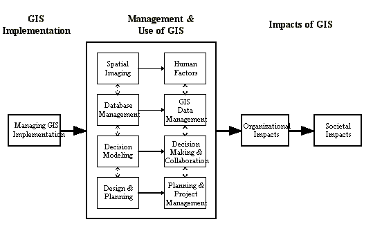
Figure 4
GIS research framework for business and management applications
As with other information systems, GIS must be managed properly to be
used effectively. Business school researchers possess a rich literature
that can be applied to studying the use of GIS in organizations (Moore
1993). For instance, an important concern facing management when adopting
a new technology is whether the technology will be accepted and used by
members of the organization. Yet, in the context of the private sector,
little has been done to examine GIS adoption and diffusion (see Campbell
and Masser 1996, for an excellent review of several case studies of
GIS adoption in the public sector), the GIS development process (Clarke
1991), and cost/benefit tradeoffs (Rhind et
al. 1991; Smith and Tomlinson 1992; Obermeyer and Pinto 1994).
This is not to say, however, that these issues have not been examined for
GIS because a number of excellent studies have examined many of these issues
in public-sector organizations (Obermeyer and Pinto
1994; Huxhold and Levinsohn 1995; Campbell and Masser 1996).
The business literature
documents a variety of experiences with the diffusion and implementation
of new information systems innovations that can be applied to GIS research
(see Kwon and Zmud 1987). For instance, several
researchers have examined technological implementation across several organizations
using both surveys and anecdotal case studies. In general, a common theme
running through several of these studies is the assumption that diffusion
occurs as a multistage process (Rogers 1983; Cooper
and Zmud 1990) and that both behavioral and organizational factors
are likely to have important impacts on the success of the implementation
(Kozar 1989; Kwon and Zmud 1987; Leonard-Barton 1987;
Leonard-Barton and DeSchamps 1988; Zmud 1982 1984). To date, no systematic,
theoretically grounded study of GIS implementation across multiple private-sector
organizations has been published.
Nevertheless, Campbell
and Masser's (1996) review of factors affecting GIS adoption and diffusion
in British local governments provides a useful starting point for examining
GIS adoption and diffusion in business settings. For example, as many researchers
studying other types of information systems have observed (e.g., Markus
1983; Markus and Robey 1988), GIS implementation is likely to be affected
by factors related to both the technology (e.g., data availability) and
human behavior (e.g., organizational politics and culture). For example,
Campbell
and Masser (1996) point out that "One of the most important aspects
of these findings is the extent to which the culture of an organization
seems to have a significant impact on its capacity to absorb change" (p.
162). Therefore, research examining the adoption and diffusion of GIS in
business organizations should consider the role of culture on the implementation
process (see Mennecke
et al. 1996).
Much also needs to be learned
about how GIS differs from other information technologies in terms of user
acceptance. User acceptance, and therefore system success, will likely
be influenced by the user's knowledge of GIS as well as their level of
training. GIS differ from other information systems in that the underlying
technologies are based on geographic and cartographic principles - principles
which are likely to be foreign to many end users. In general, people tend
to mistrust what they do not understand. Therefore, a lack of knowledge
about the underlying principles of cartography could have negative impacts
on user acceptance. In some respects, this relationship is similar to the
problems faced by users of production and logistics systems in that many
end-users often are not equipped to fully understand the principles on
which these systems are based. The solution in many business schools has
been to include courses on operations research within the distribution
requirements. Thus, an examination of pedagogical issues associated with
education in GIS principles and geographic analysis in business schools
and other academic units is needed (Aangeenbrug 1991;
Rhind et al. 1991).
The model of GIS applications presented in Figure 3 includes four core GIS functions: spatial imaging, database management, decision modeling, and design and planning. Each of these functions suggest four areas in which research on the use of GIS should focus: human factors, GIS data management, decision making and collaboration, and planning systems.
GIS and Human Factors Because
of the visual nature of GIS, issues related to the nature of the task,
the visual layout and presentation of the display, and the cognitive processes
that these issues affect in the user are all critical considerations in
the use and management of GIS. Consequently there is a great need for ongoing
research on human factors and GIS, particularly as it is adopted and used
in the private sector. A rich literature on human factors exists and can
be applied to GIS (Medyckyj-Scott and Hearnshaw 1993).
Early research about human factors in geographic data analysis studied
how humans perceive and mentally process data on maps. Therefore, much
of the early research dealt with colors, patterns and representations of
various cartographic features (Castner and Robinson
1969). For example, Bertin (1983) proposed
a taxonomy of graphical representations of data that is useful for GIS
human factors research. Bertin's research described the efficiency of human
processing associated with over 100 types of graphical displays of tabular
information. Many of the graphical constructions described by Bertin were
maps and map derivatives. Additionally, some of the preliminary research
in information systems which focused on the user interface and graphical
displays may also be useful for GIS research (e.g., Benbasat
et
al. 1986).
Fundamental to this line
of inquiry is the consideration of the physical characteristics of the
system. Issues such as the layout of features on the screen, the color
and saturation of display objects, the number and type of display objects
used, the nature of the input and output devices, and the arrangement of
the physical components of the system all have important impacts on the
way people interact with the technology (Benbasat
at.
al. 1986; Turk 1993). In this context, businesses seeking to successfully
integrate GIS into their organization must be given guidance concerning
how to properly train users as well as how to configure the layout and
display of their systems for optimal use (Turk 1993).
With the broad scope of
applications that GIS may be used for, it is also important to consider
task characteristics when studying human factors in GIS (Nyerges
1993). In particular, task characteristics such as task structure,
information symmetry, and complexity should be clearly defined in this
research (Simon 1960; Mennecke and Wheeler 1993).
Nevertheless, little research has been done to develop a comprehensive
framework which defines GIS tasks (Nyerges 1993).
A task framework is needed to provide a better understanding where GIS
should be used and how it should be applied to solve business problems
(Nyerges 1993; Turk 1993). For example, an important
question for business users of GIS is whether some of the tasks for which
they use GIS are fundamentally different from the tasks of other users
(e.g., economic planners or managers in local government). If so, this
presents numerous opportunities for research and product development.
Another important issue
in human factors research relates to the cognitive characteristics of GIS
users (Mark 1993; Turk 1993). For example, Crossland
et
al. (1993) considered spatial cognition and need for cognition
as they relate to decision-making performance in spatial problem solving.
They found that differences in individual spatial cognitive abilities had
important impacts on decision maker effectiveness and efficiency. This
suggests that more research is needed to better define how individual cognitive
characteristics influence user effectiveness. For example, in their proposed
agenda for GIS human factors research, Hearnshaw
and Medyckyj-Scott (1993) point out that "Another aspect of [user]
individuality where little is as yet known is in cognitive skills and styles"
(p. 237). A better understanding of these factors will clearly benefit
business users because user effectiveness will have important impacts on
acceptance and the requirements association with training users to properly
apply GIS to business problems (Hearnshaw 1993).
GIS Data Management Considerable
attention has been paid to various issues associated with acquiring, managing,
and using GIS attribute and spatial data. Important issues that need additional
research attention include database design (Healey
1991), data acquisition, data communication, data visualization, and
multimedia systems (Hearnshaw and Unwin 1994).
The spatial data on which GIS are built are much more complicated than
the textual/attribute data that database software has traditionally been
called on to manage (Gatrell 1991). This has
lead to considerable interest in research on database design for GIS (Healey
1991). Topics that need further research include query language design,
database model selection, error detection and quality control, the use
of knowledge-based and object-oriented databases, and distributed database
designs (Healey 1991; Maguire 1991; Rhind et al.
1991). For example, Aangeenbrug (1991) notes
that object-oriented databases have constraints when applied to spatial
data because it is not always clear how to define spatial objects. In addition,
distributed systems such as those implemented in navigation and IVHS present
special problems related to concurrency control, data distribution and
data communications (Choy et al. 1994).
Applications for GIS in
multimedia systems, including their integration into new or existing executive
information systems (EIS) and decision support systems, needs to be examined
(Laurini and Thompson 1992). In particular, both
Antenucci
et
al. (1991) and Rhind
et al. (1991)
suggest that GIS functionality will likely become encompassed into other
information systems (e.g., the recent addition of GIS display tools into
commercial spreadsheet products represent an example of this phenomenon).
Likewise, the integration
of enterprise-wide geographic technologies into data warehouse applications
will require unique procedures for capturing and managing these large,
multidimensional databases. The father of data warehousing, W. H. Inmon,
says that a data warehouse is a subject oriented, integrated, time-variant,
non-volatile collection of data in support of management's decision-making
process. In practice, most data warehouse applications are quite large,
often containing millions of records (conversely, a "data mart" is a scaled
down, less expensive, and simpler version of the data warehouse application).
In most cases, a data warehouse stores a company's business data in a single,
integrated relational database that provides a historical perspective for
decision-support applications and business queries. Data warehouse applications
can also be described as platforms for integrating diverse data in near
real-time in order to support decision making. However, today this integration
is often not based on the core geographic characteristics that are evident
in almost all data. In other words, while it is estimated that more than
80 percent of all business data can be linked by some type of geographic
component, these spatial characteristics are too often not factored into
the design of data warehouses. By enabling data warehouse applications
to leverage geographical relationships, geographic technologies like ESRI's
Spatial Database Engine (SDE) can be used to create, improve, or enable
processes in a variety of ways that were impractical or difficult using
other, non-spatial technologies. To date, only a few spatial data warehouse
applications have been implemented or described in the literature (Létourneau
et
al. 1997). Thus, much research is needed to understand how to design,
implement, and manage these resources.
Decision Making and Collaboration Often
GIS are used only as a tool to query a database or as a vehicle for displaying
maps and spatial imagery. In this context, GIS represents an important
enhancement to traditional database management systems and presentation
graphics tools because it provides the decision maker with a powerful way
to organize, retrieve, and display data based on its spatial characteristics.
However, as noted above, GIS can also be employed as a tool to support
more sophisticated manipulations and analyses of data. For example, most
current GIS incorporate transformational and statistical functions and
thus can be used to manipulate data and develop analyses and projections.
Even though GIS provide researchers with capabilities that are not present
in other information systems, little has been done to examine the efficacy
and efficiency of GIS functionality in supporting decision making. One
of the few reported studies of GIS supported decision making did find that
GIS enables the decision maker to answer complex questions more quickly
and more accurately compared to decision makers using paper maps (Crossland
et
al. 1995). Nevertheless, more needs to be done to precisely evaluate
whether and how various GIS functions, tools, and displays influence the
quality of the user's decisions, their satisfaction, and other variables
related to decision making. For example, more research is needed to examine
the impacts of varying display characteristics, data representations, and
map projections on decision making. In addition, research is also needed
to examine the use and value of various spatial analysis tools in decision
making (Openshaw 1991). Finally, research should
examine and identify those types of data and problem situations where GIS
is an appropriate decision making tool as well as those situations where
other types of tools might be more appropriate.
Furthermore, as is the case
with other information systems, many decisions supported by GIS are actually
made in or by groups of people working collaboratively (Campbell
and Masser 1996). For example, organizations such a Yellow Freight
and SYLVANIA have integrated GIS into "War Rooms" and group conference
facilities. Nevertheless, it would be advantageous if GIS were able to
function as an integrated part of a greater number of collaborative information
systems. Recent efforts with using shared drawing tools to augment computer
supported collaborative work (CSCW) systems represents a viable model for
collaborative GIS tools. One example of a collaborative drawing tool, Graphics
COPE, allows groups of users to simultaneously develop a single cognitive
map of a particular problem and/or solution (Nagasundaram
1993). Graphic manipulation tools for GIS that would allow users that
are geographically dispersed to share maps, data, and other information
would provide a powerful environment for decision making and collaboration.
Unfortunately, published research on collaborative GIS (or CGIS)
is scarce. However, organizations supporting GIS and spatial data analysis
such as the National Center for Geographic Information and Analysis (NCGIA)
have begun to examine this issue (Densham at al.
1995) and research examining group decision making involving spatial
data is beginning to appear (see Malczewski 1996).
A rich literature on group decision support systems (GDSS), CSCW, and decision
support systems (DSS) exists and would provide a useful resource for application
development and research on this topic (see Nunamaker
et
al. 1991; Valacich et al. 1991; Jessup and Valacich 1993
).
Planning and Project ManagementOf
the GIS functions shown in Figure 3, the planning
and design function is one of the most well developed and best understood.
Thus, the opportunities for research in this area are fewer in scope than
those associated with the other GIS functions. Nevertheless, those applications
that have yet to be adequately addressed or developed represent promising
opportunities for research. For example, although GIS and CAD systems are
important technologies for designing plans, blueprints, and maps, GIS applications
associated with project management and planning are less well developed.
Part of the reason for this is that it is often difficult to represent
temporal data and temporal changes in spatial data (Rhind
et al. 1991). Nevertheless, GIS functionality could be helpful
in systems that are used to manage and plan a variety of projects. For
example, the applications of GIS for logistical problems associated with
the decision modeling function have been highlighted above. Other planning
and project management applications for GIS functionality might be examined.
GIS and related technologies might, for example, be useful for representing
conceptual models of new or revised business or task processes. In addition,
many CASE tools use graphical representations of entities and objects that
will be incorporated into software or databases. The ability of GIS to
represent data in multiple layers may be useful in enhancing the capabilities
of current CASE technologies. Thus, further research is needed to identify
new ways of incorporating GIS capabilities into systems designed for planning
and project management.
As GIS diffuse into various organizations, they are likely to have significant impacts on the structure and operation of these organizations. Furthermore, as GIS becomes more pervasive, it is also likely to have greater impacts on the society as a whole. Prior research on information systems have found that they can have important and, in some cases, unanticipated impacts on power, politics, and organizational design. GIS is a tool with the potential to improve activities related to decision making, planning, and information exchange. Information systems that change organizational patterns of information exchange or information availability have the potential to significantly change both the power and political structures within organizations (Markus 1983; Davenport et al. 1992). GIS is likely to change the information flow within organizations and therefore the distribution of power should be expected to change as well (Demers and Fisher 1991; Peuquet and Bacastow 1991). In addition, as information distribution patterns change, so too should the form of the organization (Aangeenbrug 1991). For example, greater interdepartmental collaboration should be expected as organizational units are increasingly called on to share data and other GIS resources (Demers and Fisher 1991). This will likely be more important as new enterprise-wide GIS technologies are used to distribute spatial data across multiple organizational units. Thus, future research should focus on the relationship between collaboration, organizational communication, and GIS adoption.
With the arrival of most new technologies also comes the potential for
impacts, both positive and negative, on the society in which the technology
is used. GIS is no different. For example, GIS has been used for several
years in developed countries such as the United States and the United Kingdom
for public policy and political applications. As GIS technology diffuses
into a greater number of government and business organizations, increasing
societal benefits derived from more efficient and effective decision making
and planning should be realized. For example, the author is currently working
on a project to examine several United States Department of Labor initiatives
that incorporate spatial data (Killingsworth et
al. 1996). For example, the America's Job Bank (5)
will incorporate GIS functionality in a system that is designed for use
by individual job seekers. This system will enable a variety of untrained
users to utilize detailed maps to display information about employer locations,
public transportation, and major road networks. Systems like this, which
bring geographic technology to a multitude of users who normally do not
have access to sophisticated spatial-analysis technologies, are expected
to help to make labor markets more efficient and thereby reduce unemployment.
Further, this type of application will have important impacts on employers
both by improving their ability to fill positions and by increasing competition
for labor supplies.
Likewise, as GIS diffuses
into underdeveloped countries, research should focus on how cultural difference,
data accessibility, user education, and political systems influence GIS
use, effectiveness, and diffusion (see Taylor1991;
Rhind 1992). Furthermore, as GIS is increasingly used in the public
sector, the public should also benefit because of increased access to and
availability of data generated through public sector agencies. For example,
data generated by the Census Bureau (i.e., TIGER files) have become the
foundation for and impetus behind much of the recent growth in GIS use
in the United States. Future research should focus both on how public sector
GIS use and data production influence the private sector and how organizations
manage the implementation process.
With increased GIS use and
data accessibility comes the potential for negative impacts on society.
For instance, issues related to errors and misrepresentation of both spatial
data and demographic data can potentially result in legal liability for
data purveyors and users (Epstein 1991). In addition,
increased access to data pertaining to private citizens and private sector
organizations can also potentially lead to abuse and misrepresentation
(Rhind et al. 1991; Abrams 1994). Future
research should examine the legal and privacy issues associated with GIS.
GIS is important in business because most business problems include
significant spatial components and GIS enables decision makers to leverage
their spatial data resources more effectively. While most organizations
have an intense desire to know their customers, they often possess an incomplete
paradigm of the actual data that describe their customers. The process
of defining and extending organizational knowledge about customers - which
includes providing necessary process improvements and tools to actually
sense, describe, and respond to customers - can be significantly enabled
by geographic technologies. GIS is useful for managing databases, even
extremely large applications such as data warehouses, because it provides
an enhanced data structure that is based on the natural organization that
geography provides. In other words, data can be organized in a spatial
order; the very same organizational order that is used by most managers
when they think about their operations and markets. Today, GIS-based data
sources vary from satellite imagery used to validate the number of new
houses in a retail-market to the individual people-point data of the consumers
living in those houses. Data such as these can add significant value to
an organization's database by helping to validate and extend their own
proprietary resources.
Because of these and other
reasons, GIS is moving quickly into the private sector, yet few members
of the business research community have actively examined this technology
to date. As this paper has attempted to show, many opportunities exist
for research on business applications for geographic technologies. For
example, more information about managing GIS through the implementation
and operational phases of its life-cycle is needed. In addition, research
needs to examine issues related to organizational impacts of GIS, collaborative
issues, decision-making effectiveness, and factors affecting human perception
and cognition. Finally, much needs to be done to examine the societal impacts
of GIS in both developed and developing countries. As GIS continues to
diffuse into the private sector, organizational researchers should be ready
to contribute their expertise to generating a better understanding this
technology and its role in managing and operating business organizations.
Aangeenbrug, R.T. (1991) A Critique of GIS. In: Geographic Information Systems: Principles and Applications, Vol. 1, editied by D.J. Maguire, M.F. Goodchild, and D.W. Rhind, pp. 101-107. London: Longman Scientific and Technical.
Abrams, M.E. (1994) Valuing Privacy in the Information Age, GeoInfo Systems, 4:6, 26-28.
Antenucci, J.C., Brown, K., Croswell, P.L., and Kevany, M.J. (1991) Geographic Information Systems: A Guide to the Technology. New York, N.Y.: Van Nostrand Reinhold.
Battista, C. (1994) Billboard Companies Drop Pushpins for Geographic Technologies. Business Geographics, 2:3, 34-35.
Battista, C. (1995) Competition in the Food Chain. Business Geographics, 3:3, 32-34.
Bertin, J. (1983) Semioloy of Graphics: Diagrams, Networks, Maps. Translation by W. J. Berg. Madison: University of Wisconsin Press.
Benbasat, I., Dexter, A.S., and Todd, P. (1986). An Experimental Program Investigating Color Enhanced and Graphical Information Presentation: An Integration of the Findings. Communications of the ACM, 29:11, 1094-1105.
Burrough, P.A. (1986) Principles of Geographic Information Systems for Land Resources Assessment. Oxford: Clarendon.
Campbell, H., and Masser, I. (1996) GIS and Organizations: How Effective are GIS in Practice?. London, UK: Taylor and Francis, Ltd.
Carter, J.R. (1989) On Defining the Geographic Information System. In W. J. Ripple (ed.), Fundamentals of Geographic Information Systems: A Compendium. Falls Church, VA: ASPRS/ACSM, 3-7.
Castner, H.W. and Robinson, A.H. (1969) Dot Area Symbols in Cartography: The Influence of Pattern on their Perception. Technical Monograph No. CA-4. Washington, DC: American Congress on Surveying and Mapping, Cartography Division.
Cheu, D. (1994) Serving the Client Better with Client/Server Business Geographics, Business Geographics, 2:2, 32-33.
Choy, M., Kwan, M.P., and Leong, H.V. (1994) On Real-Time Distributed Geographic Database Systems. Proceedings of the Hawaii International Conference on System Sciences, Vol. IV, held in January, 1994, pp. 337-346. Los Alamitos, CA: IEEE Society Press.
Chrisman, N.R. (1991) The Error Component in Spatial Data. In: Geographic Information Systems: Principles and Applications, Vol. 1, editied by D.J. Maguire, M.F. Goodchild, and D.W. Rhind, pp. 165-174. London: Longman Scientific and Technical.
Clarke, A.L. (1991) GIS Specification, Evaluation and Implementation. In: Geographic Information Systems: Principles and Applications, Vol. 1, editied by D.J. Maguire, M.F. Goodchild, and D.W. Rhind, pp. 477-488. London: Longman Scientific and Technical.
Cooke, D.F. (1992) Spatial Decision Support System: Not Just Another GIS. GeoInfo Systems, 2:5, 46-49.
Cooper, R.B., and Zmud, R.W. (1990) Information Technology Implementation Research: A Technological Diffusion Approach. Management Science, 36:2, 123-139.
Coppock, J.T. and Rhind, D.W. (1991) The History of GIS. In: Geographic Information Systems: Principles and Applications, Vol. 1, editied by D.J. Maguire, M.F. Goodchild, and D.W. Rhind, pp. 21-43. London: Longman Scientific and Technical.
Cowen, D.J. (1988). GIS Versus CAD Versus DBMS: What Are the Differences? Photogrammetric Engineering and Remote Sensing, 54:11, 1551-1554.
Crossland, M.D., Perkins, W.C., and Wynne, B.E. (1995) Spatial Decision Support Systems: An Overview of Technology and a Test of Efficacy. Decision Support Systems, 14, 219-235.
Crossland, M.D., Scudder, J.N., Herschel, R.L, and Wynne, B.E. (1993). Measuring the Relationships of Task and Cognitive Style Factors and Their Effects On Individual Decision-Making Effectiveness Using a Geographic Information System. Proceedings of the Hawaii International Conference on System Sciences, Vol. IV, held in January, 1993, pp. 575-584. Los Alamitos, CA: IEEE Society Press.
Davenport, T.H., Eccles, R.G., and Prusak, L. (1992) Information Politics. Sloan Management Review, 45, 53-65.
Demers, M.N., and Fisher, P.F. (1991) Comparative Evolution of Statewide Geographic Information Systems in Ohio. International Journal of Geographical Information Systems, 5:4, 469-485.
Densham, P.J. (1991). Spatial Decision Support Systems. In: Geographic Information Systems: Principles and Applications, Vol. 1, editied by D.J. Maguire, M.F. Goodchild, and D.W. Rhind, pp. 403-412. London: Longman Scientific and Technical.
Densham, P.J., Armstrong, M.P., and Kemp, K. K. (1995) Collaborative Spatial Decision-Making: Scientific Report for the Intitiative 17 Specialist Meeting. Orono, Maine: National Center for Geographic Information and Analysis.
Department of the Environment (1987) Handling Geographic Information. London: HMSO.
Devine, H.A., and Field, R.C. (1986) The Gist of GIS. Journal of Forestry, 8, 17-22.
Dueker, K.J. (1979) Land Resource Information Systems: A Review of Fifteen Years Experience. Geo-Processing, 1, 105-128.
Epstein, E.F. (1991) Legal Aspects of GIS. In: Geographic Information Systems: Principles and Applications, Vol. 1, editied by D.J. Maguire, M.F. Goodchild, and D.W. Rhind, pp. 489-502. London: Longman Scientific and Technical.
Francese, P., and Piirto, R. (1990) Capturing Customers: How to Target the Hottest Markets of the '90s. Ithaca, NY: American Demographics Books.
Gatrell, A.C. (1991) Concepts of Space and Geographic Data. In: Geographic Information Systems: Principles and Applications, Vol. 1, editied by D.J. Maguire, M.F. Goodchild, and D.W. Rhind, pp. 119-134. London: Longman Scientific and Technical.
Goodchild, M.F. (1992). Geographical Information Science. International Journal of Geographical Information Systems, 6:1, 31-45.
Grabowski, M., and Sanborn, S. (1992) Knowledge Representation and Reasoning in a Real-Time Operational Control System: The Shipbboard Piloting Expert System (SPES). Decision Sciences, 23, 1277-1296.
Healey, R.G. (1991) Database Management Systems. In: Geographic Information Systems: Principles and Applications, Vol. 1, editied by D.J. Maguire, M.F. Goodchild, and D.W. Rhind, pp. 251-267. London: Longman Scientific and Technical.
Hearnshaw, H.M. (1993) Learning to Use a GIS. In: Human Factors in Geographical Information Systems, edited by D. Medyckyj-Scott and H.M. Hearnshaw, pp. 70-80. London, UK: Belhaven Press.
Hearnshaw, H.M., and Medyckyj-Scott, D. (1993). The Way Forward for Human Factors in GIS. In: Human Factors in Geographical Information Systems, edited by D. Medyckyj-Scott and H.M. Hearnshaw, pp. 235-243. London, UK: Belhaven Press.
Hearnshaw, H.M., and Unwin, D.J. (1994) Visualization in Geographical Information Systems. New York, NY: John Wiley and Sons, Inc.
Hoerning, R. (1996). American Honda Jump-Starts Sales Geographically. Business Geographics, 4:3, 24-26.
Huxhold, W.E., and Levinsohn, A.G. (1995) Managing Geographic Information System Projects. Oxford, UK: Oxford University Press.
Jessup, L.M. and Valacich, J.S. (1993) Group Support Systems: New Perspectives. New York, NY: Macmillan.
Juhl, G.M. (1994) Reengineering the Enterprise: Reaping the Technology Payoff of AM/FM/GIS. GeoInfo Systems, 4:1, 32-39.
Killingsworth, B.L., Mennecke, B.E., Schellenberger, R.E., and Mcleod, M. (1996) Information Systems Use in the Service of the Public: Experiences And Opportunities for Using Geographic Information Systems to Support America's Labor Market Information System Employer Database. Proceedings of the Twenty-Seventh Meeting of the Decision Sciences Institute.
Koshkariov, A.V., Tikunov, V.S., and Trofimov A.M. (1989) The Current State and the Main Trends in the Development of Geographical Information Systems in the USSR. International Journal of Geographical Information Systems, 3:3, 257-272.
Kozar, K.A. (1989) Adopting Systems Development Methods: An Exploratory Study. Journal of Management Information Systems, 5:4, 73-86.
Kunze, E.A. (1993) GIS Delivers Logistics Solutions to UPS. Business Geographics, 1:4, 34-37.
Kwon, T.H., and Zmud, R.W. (1987) Unifying the Fragmented Models of Information Systems Implementation. In: Critical Issues in Information Systems Research, edited by R.J. Boland and R.A. Hirschheim, pp. 227-251. New York, NY: John Wiley and Sons, Inc.
Landis, J.D. (1993) GIS Capabilities, Uses, and Organizational Issues. In: Profiting From A Geographic Information System, edited by G.H. Castle, pp. 23-53. Fort Collins, CO: GIS World, Inc.
Lang, L. (1996a) The Telecommunications Showdown. Business Geographics, 4:1, 30-32.
Lang, L. (1996b) Beyond the Gas Pump. Business Geographics, 4:6, 26-30.
Lapalme, G., Rousseau, J.M., Chapleau, S., Cormier, M., Cossette, P., and Roy, S. (1992) GeoRoute: A Geographic Information System for Transportation Applications. Communications of the ACM, 35:1, 80-94.
Laurini, R., and Thompson, D. (1992) Fundamentals of Spatial Information Systems. London: Academic Press, Ltd.
Leonard-Barton, D. (1987) Implementing Structured Software Methodologies: A Case of Innovation in Process Technology. Interfaces, 17:3, 6-17.
Leonard-Barton, D., and DeSchamps, I. (1988) Managerial Influence in the Implementation of New Technology. Management Science, 34:10, 1252-1265.
Létourneau, F., Bédard, Y., and Proulx, M.J. (1997) SOS-SD: A Data Warehouse-Based System for the Optimized Selection of Spatial Data. D-lib Magazine, March, http://www.dlib.org/dlib/march97/laval/03letourneau.html.
Leung, Y., and Leung, K.S. (1993a) An Intelligent Expert System Shell for Knowledge-Based Geographical Information Systems: 1. The Tools. International Journal of Geographical Information Systems, 7:1, 189-200.
Leung, Y., and Leung, K.S. (1993b) An Intelligent Expert System Shell for Knowledge-Based Geographical Information Systems: 2. Some Applications. International Journal of Geographical Information Systems, 7:1, 201-214.
Maguire, D.J. (1991) An Overview and Definition of GIS. In: Geographic Information Systems: Principles and Applications, Vol. 1, editied by D.J. Maguire, M.F. Goodchild, and D.W. Rhind, pp. 9-20. London: Longman Scientific and Technical.
Malczewski, J. (1996) A GIS-Based Approach to Multiple Criteria Group Decision-Making. International Journal of Geographical Information Systems, 10:8, 955-971.
Mark, D.M. (1993) Human Spatial Cognition. In: Human Factors in Geographical Information Systems, edited by D. Medyckyj-Scott and H.M. Hearnshaw, pp. 51-60. London, UK: Belhaven Press.
Markus, M.L. (1983) Power, Politics, and MIS Implementation. Communications of the ACM, 26:6, 430-444.
Markus, M.L., and Robey, D. (1988) Information Technology and Organizational Change: Causal Structure in Theory and Research. Management Science, 34, 583-598.
Masser, I., and Onsrud, H.J. (1993) Diffusion and Use of Geographic Information Technologies. Dordrecht, Netherlands: Kluwer Academic Publishers.
McKenna, R. (1995) Real-Time Marketing. Harvard Business Review (July-August), 87-95.
Medyckyj-Scott, D., and Hearnshaw, H.M. (1993) Human Factors in Geographical Information Systems. London, UK: Belhaven Press.
Mennecke, B.E., Dangermond, J., Santoro, P.J., and Darling, M. (in press) Responding to Customer Needs with Geographic Information Systems, In: Sense and Respond: Capturing Value in the Network Era, edited by S. Bradley and R. Nolan. Boston MA: Harvard Business School Press.
Mennecke, B.E., Hauser, R., and Byrd, T. (1996) Implementing Geographic Information Systems: The Impact of Organizational Culture and Use, Proceedings of the Business Geographics for Educators and Researchers Conference.
Mennecke, B.E., and Wheeler, B.C. (1993) Task Matters: Modeling Group Task Processes in Experimental CSCW Research, Proceedings of the Hawaii International Conference on System Sciences, Vol. IV, held in January, 1993, pp. 71-80. Los Alamitos, CA: IEEE Society Press.
Montgomery, G.E. (1995) What Really Drives GIS Procurement in Utilities? GIS World, 8:7, 74.
Moore, G.C. (1993) Implications From MIS Research for the Study of GIS Diffusion: Some Initial Evidence. In: Diffusion and Use of Geographic Information Technologies, edited by I., Masser, and H.J. Onsrud, pp. 77-94. Dordrecht, Netherlands: Kluwer Academic Publishers.
Nagasundaram, M. (1993) Cognitive Mapping for Better Group Decisions. Groupware Report, 2:5, 6-7.
Nunamaker Jr., J.F., Dennis, A.R., Valacich, J.S., and Vogel, D.R. (1991) Information Technology for Negotiating Groups: Generating Options for Mutual Gain. Management Science, 37:10, 1325-1346.
Nyerges, T.L. (1993) How Do People Use Geographical Information Systems? In: Human Factors in Geographical Information Systems, edited by D. Medyckyj-Scott and H.M. Hearnshaw, pp. 37-50. London, UK: Belhaven Press.
Obermeyer, N.J., and Pinto, J.K. (1994) Managing Geographic Information Systems. New York, NY: Guilford Press.
Onsrud, H.J., and Pinto, J.K. (1991) Diffusion of Geographic Information Innovations. International Journal of Geographical Information Systems, 5:4, 447-467.
Openshaw, S. (1991). A Spatial Analysis Research Agenda. In: Handling Geographic Information, edited by I. Masser and M. Blakemore, pp. 18-37. New York, NY: John Wiley and Sons, Inc.
Ozemoy, V.M., Smith, D.R., and Sicherman, A. (1981) Evaluating Computerized Geographic Information Systems Using Decision Analysis. Interfaces, 11, 92-98.
Parker, H.D. (1988) The Unique Qualities of a Geographic Information System: A Commentary. Photogrammetric Engineering and Remote Sensing, 54:11, 1547-1549.
Peuquet, D.J., and Bacastow, T. (1991) Organizational Issues in the Development of Geographic Information Systems: A Case Study Of U.S. Army Topographic Information Automation. International Journal of Geographical Information Systems, 5:3, 303-319.
Raper, J.F. (1991) User Interfaces. In: Handling Geographic Information, edited by I. Masser and M. Blakemore, pp. 102-114. New York, NY: John Wiley and Sons, Inc.
Raper, J.F. and Kelk, B. (1991) Three-Dimensional GIS. In: Geographic Information Systems: Principles and Applications, Vol. 1, editied by D.J. Maguire, M.F. Goodchild, and D.W. Rhind, pp. 299-317. London: Longman Scientific and Technical.
Rector, J.M. (1993) Utilities. In: Profiting From a Geographic Information System, Edited by G.H. Castle, pp. 193-208. Fort Collins, CO: GIS World, Inc.
Rhind, D. (1992) Data Access, Charging and Copyright and Their Implications for Geographical Information Systems. International Journal of Geographical Information Systems, 6:1, 13-30.
Rhind, D.W., Goodchild, M.F., and Maguire, D.J. (1991) Epilogue. In: Geographic Information Systems: Principles and Applications, Vol. 2, editied by D.J. Maguire, M.F. Goodchild, and D.W. Rhind, pp. 313-327. London: Longman Scientific and Technical.
Rogers, E.M. (1983) Diffusion of Innovations. New York, NY: The Free Press.
Sherwood-Bryan, N. (1994) Marks and Spencer Maps It Out. Business Geographics, 2:3, 36-37.
Sherwood, N. (1995). Increased Competition Pushes the Beverage Industry to Streamline Logistics. Business Geographics, 3:2, 24-27.
Simon, H.A. (1960) The New Science of Management Decision. New York, NY: Harper and Row.
Simon, H.A. (1976) Administrative Behavior (3rd ed.). New York: Macmillan.
Skidmore, A.K., Ryan, P.J., Dawes, W., Short, D., and O'Loughlin, E. (1991) Use of an Expert System to Map Forest Soils from a Geographical Information Systems. International Journal of Geographical Information Systems, 5:4, 431-446.
Smith, D.A., and Tomlinson, R.F. (1992) Accessing Costs and Benefits of Geographical Information Systems: Methodological and Implementation Issues. International Journal of Geographical Information Systems, 6:3, 247-256.
Smith, T.R., Menon, S., Starr, J., and Estes, J. (1987) Requirements and Principles for the Implementation and Construction of Large-Scale Geographic Information Systems. International Journal of Geographical Information Systems, 1:1, 13-31.
Smith, T.R. and Yiang, J. (1991) Knowledge-Based Approaches in GIS. In: Geographic Information Systems: Principles and Applications, Vol. 1, editied by D.J. Maguire, M.F. Goodchild, and D.W. Rhind, pp. 413-425. London: Longman Scientific and Technical.
Sprague, R.H. (1980) A Framework for the Development of Decision Support Systems. Management Information Systems Quarterly, 4, 1-26.
Taylor, D.R.F. (1991) GIS and Developing Nations. In: Geographic Information Systems: Principles and Applications, Vol. 2, editied by D.J. Maguire, M.F. Goodchild, and D.W. Rhind, pp. 71-84. London: Longman Scientific and Technical.
Turban, E. (1995) Decision Support and Expert Systems, 4th Edition. Englewood Cliffs, NJ: Prentice Hall.
Turk, A. (1993) The Relevance of Human Factors to Geographical Information Systems. In: Human Factors in Geographical Information Systems, edited by D. Medyckyj-Scott and H.M. Hearnshaw, pp. 15-31. London, UK: Belhaven Press.
Unwin, D.J. (1991) The Academic Setting of GIS. In: Geographic Information Systems: Principles and Applications, Vol. 1, editied by D.J. Maguire, M.F. Goodchild, and D.W. Rhind, pp. 81-90. London: Longman Scientific and Technical.
Vaidya, A.G., and Lang, L. (1994) When Information is Everyone's Business: ConRail Opens Information Access and Use by Linking Geographic Data. Business Geographics, 2:2, 24-26.
Valacich, J.S., Dennis, A.R., and Nunamaker, J.F. (1991) Electronic Meeting Support: The GroupSystems Concept. International Journal on Man-Machine Studies, 34, 261-282.
Webster, F.E. (1994) Defining the New Marketing Concept. Marketing Management, 2:4, 23-31.
Wendelken, S. (1994) SYLVANIA Lights Up Sales with The Source. Business Geographics, 2:7, 22-25.
White, M. (1991) Car Navigation Systems. In: Geographic Information Systems: Principles and Applications, Vol. 2, editied by D.J. Maguire, M.F. Goodchild, and D.W. Rhind, pp. 115-125. London: Longman Scientific and Technical.
Wu, J.K., Chen, T., and Yang, L. (1988) QPF: A Versatile Query Language for Knowledge-Based Geographical Information Systems. International Journal of Geographical Information Systems, 3:1, 51-58.
Zmud, R.W. (1982) Diffusion of Modern Software Practices: Influence of Centralization and Formalization. Management Science, 28:12, 1421-1431.
Zmud, R.W. (1984) An Examination of 'Push-Pull' Theory Applied to Process Innovation in Knowledge Work. Management Science, 30:6, 727-738.
Footnotes:
(1)I am using a DSS model
as the basis for defining GIS components because most of today's GIS systems
incorporate the components present in a DSS. Densham
(1991) used the term spatial decision support system (SDSS)
to describe a system that "
normally is implemented for a limited problem
domain. The database integrates a variety of spatial and non-spatial data
and facilitates the use of analytical and statistical modelling techniques.
A graphical interface conveys information, including the results of analyses,
to decision makers in a variety of forms. Finally, the system both adapts
to the decision maker's style of problem solving and is easily modified
to include new capabilities." (p. 406). As implemented today, most commercial
GIS, and particularly desktop GIS, fall into this definition of SDSS. On
the other hand, Cooke (1992) suggested a more
narrow definition of SDSS by suggesting that they are easy-to-use, 'canned'
tools for spatial analysis. Therefore, I prefer to use the broader term
of 'GIS.'
(2) These and several
of the subsequent examples are drawn from the author's experiences interacting
with companies as well as information drawn from news announcements in
industry and vender publications such as ArcNews.
(3)
For example, MapBlast (http://www.mapblast.com)
is a site that generates street maps and ESRI (http://www.esri.com)
has a set of interactive maps that are implemented using MapObjects, its
object-oriented mapping tool.
(4) See http://www.visa.com
(5) See http://www.ajb.dni.us/
![]() JGIDA
vol.1, no.1
JGIDA
vol.1, no.1
![]() JGIDA
Home
JGIDA
Home
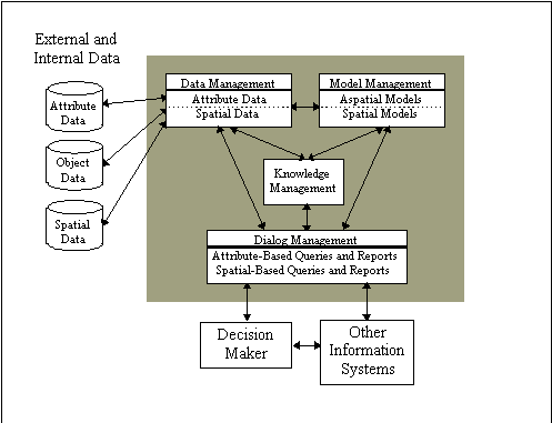