
Robert J. Tkach
Department of Civil and Geological
Engineering and Natural Resources Institute, The University of Manitoba,
Winnipeg, MB R3T 2N2, Canada
rob@fids.ce.umanitoba.ca
http://www.ce.umanitoba.ca/~rob/
Slobodan P. Simonovic
Department of Civil and Geological
Engineering and Natural Resources Institute, The University of Manitoba,
Winnipeg, MB R3T 2N2, Canada
simon@ce.umanitoba.ca
http://www.ce.umanitoba.ca/~simon/
Contents
1.
Introduction
Selecting the best strategy from a number of potential alternatives
in water resources planning and management is a complex decision making
process (Bose and Bose 1995). It may include
conflicting quantitative and qualitative criteria and multiple decision-makers.
The decision-making process can benefit from the use of multi-criteria
decision making (MCDM) techniques. They can be used to facilitate the decision-making
process by making the process more explicit, rational, and efficient (Hobbs
et al. 1992). Conventional MCDM techniques have been used in the
field of water resources in the past (Simonovic 1989;
Shafike et al. 1992; and Greshan et al. 1982).
The evaluation and ranking
of alternatives by MCDM techniques is based on criteria values associated
with each of the alternatives, and the objectives and preferences of the
various decision makers. The criteria used in the evaluation of water resources
alternatives, which may be quantitative and/or qualitative, often exhibit
spatial variability. For example, implementation of a particular alternative
could produce favorable impacts at one location while resulting in negative
consequences at another. Conventional MCDM techniques are not able to address
uneven spatial distribution of the criteria values in the evaluation and
ranking of alternatives.
The main objective of the
research described in this paper is to develop a MCDM technique capable
of capturing the spatial distribution of the criteria values associated
with the various alternatives. The new MCDM technique developed in this
research, named Spatial Compromise Programming (SCP) combines the Compromise
Programming (CP) (Zeleny 1973) with Geographic
Information System (GIS) technology.
The analysis of potential
floodplain management strategies for the Red River Valley is used as a
case study to demonstrate the potential of the SCP technique. The main
objective of the case study is to generate, evaluate, and rank a set of
potential flood protection alternatives. The flood water impacts occurring
under the implementation of different protection alternatives are used
to evaluate and rank the alternatives using both, CP and SCP techniques.
Through the application of the CP technique the best alternative is determined
for the entire region. The best alternative for each location within the
region is determined using SCP. Comparison of the results produced through
the application of the two techniques is used to identify the merits of
the new approach (SCP).
The remainder of the paper
contains a description of the development, application, and evaluation
of the Spatial Compromise Programming technique. The next section begins
with an overview of the use of GIS in decision making. A brief description
of the Compromise Programming technique follows. With the help of a very
simple example, the shortcomings of this technique for spatial decision
making are identified. The following section of the paper describes the
Spatial Compromise Programming technique. Using the same simple example,
the mechanics of SCP are illustrated. The final section of this paper describes
the case study. The paper concludes with a discussion and comparison of
the evaluation of the flood control alternatives using Compromise Programming
and Spatial Compromise Programming.
Geographic Information Systems are a rapidly evolving technology that
can be used for the efficient storage, analysis, and management of spatial
information. Environmental or natural resources management decisions almost
always require the analysis of spatial information. GIS technologies have
been used to facilitate decision making in the field of water resources
and many other fields of study. Carver (1991)
presents an example application of the integration of multi-criteria evaluation
techniques with GIS in searching for suitable sites for the disposal of
radioactive waste in the UK. McKinney and Maidment
(1993) combine a GIS with Expert System technology to enhance the decision-making
process in water resources management. Given existing and projected water
supplies and demands combination of the two technologies determines potential
water deficits and surpluses. Pereira and Duckstein
(1993) apply the Compromise Programming technique within a GIS in order
to evaluate potential habitats for the endangered Mount Graham red squirrel.
Applications in other areas include Banai (1993),
Tim
(1997), and Wolfe (1997).
GIS technologies facilitate
the decision making process based on their analytical capabilities with
spatial information. In addition to this, many of them are equipped with
a graphical user interface, which increases the decision-maker's comprehension
of the spatial information that is involved in the problem being addressed.
Based on these two potential additions to the decision making process,
a GIS is often included as a major component in the development of Decision
Support Systems (DSS). Because of the spatial component that a GIS adds
to conventional DSS, this combination of technologies has been referred
to as Spatial Decision Support Systems (SDSS). Recent papers by Walsh
(1993), Fürst et al. (1993),
Simonovic
(1993), Leipnik
et al. (1993), Watkins
et
al. (1996), and Fedra (1997) discuss
the potential applications of SDSS in environmental and natural resources
decision making.
MCDM is characterized by great methodological diversity with three main groups of techniques: (a) outranking techniques; (b) multi-attribute utility techniques; and (c) mathematical programming techniques (Goicoechea at al. 1982). Outranking techniques require pairwise or global comparisons among alternatives, which are not practical where the number of alternatives is large. Multi-attribute utility techniques rely on linear additive or simple multiplicative models for aggregating single criterion evaluations. They are not appropriate for the analysis of complex environmental systems. Compromise Programming (CP) is a mathematical programming technique for use in a continuous context (Zeleny 1973). It has also been modified for water resources multi-criteria discrete problems (Duckstein and Opricovic 1980). It is used to identify solutions that are closest to the ideal solution as determined by some measure of distance. The solutions identified to be closest to the ideal solution are called compromise solutions and constitute the compromise set. The ideal solution is one which provides the extreme value for each of the criteria considered in the analysis. The distance from the ideal solution for each alternative is measured by what is referred to as the distance metric. This value, which is calculated for each alternative solution, is a function of the criteria values themselves, the relative importance of the various criteria to the decision makers, and the importance of the maximal deviation from the ideal solution (Simonovic 1989). Shown in Equation (1) is the operational expression used to compute the family of distance metrics (Lj) for a set of n criteria and m alternatives.
where:
Lj is the distance metric;
f*i is the optimal value of the ith
criteria;
fi,w is the worst value of the ith
criteria;
fi,j is the value of the ith
criteria for alternative j;
wi are weights indicating decision maker preferences;
p is a parameter (1£ p £
¥);
i is indicates the number of criteria i = 1,
,n;
and
j is indicates the number of alternatives j = 1,
,m.
Introduction
of wi allows the expression of the decision makers' preferences
concerning the relative importance of various criteria. The parameter p
reflects the importance of the maximal deviation from the ideal point.
Thus a double-weighting scheme exists: for p = 1 all deviations
are weighted equally; for p = 2 each deviation is weighted in proportion
to its magnitude. The larger the deviation the larger the weight. For the
value of p = ¥, the min-max criterion
is achieved (Simonovic 1989).
In using CP and many other
MCDM techniques to evaluate a set of potential alternatives a single optimal
solution that equally satisfies all criteria is often infeasible. Instead
of seeking a single optimal solution, a subset of noninferior (nondominated)
solutions is sought. For each solution, which is outside the nondominated
subset but still within the feasible region, there is a nondominated solution
for which all criteria are unchanged or improved and at least one that
is strictly improved (Goicoechea et al. 1982).
Generation of the nondominated set of alternatives is accomplished using
the CP technique by solving Equation (1) for
different values of the weight p. As the range of the weight p
is infinite, further reduction of the set is necessary for practical application.
Typically, the compromise set is approximated by solving Equation (1)
using values of p = 1, 2 and ¥.
The criteria values used
in Equation (1) express impacts produced by,
or characteristics associated with each of the alternatives. It is obvious
that in Equation (1) there is no consideration
for potential spatial variability in the criteria values. Therefore in
identifying the best compromise solutions using CP, only the region as
a whole is considered, and local impacts associated with different alternatives
are ignored.
2.3. Importance of Spatial Variation in Criteria Values
The criteria used in water resources are often spatially variable. For example, in flood control, the impacts produced by flooding are typically not the same for all locations within the floodplain. The distribution of the flood impacts is a function of the implemented flood protection measures. Implementation of a particular measure may reduce flood impacts at one location, while providing no protection at all for another. Straightforward application of conventional MCDM techniques are not appropriate for problems which exhibit spatial variability in the criteria values. Conventional MCDM techniques typically use average or total impacts incurred across the entire region being considered. The following is a very simple example that demonstrates the existence of spatial variability in the criteria values. The same example is then used to analyze the implications of not considering the spatial variation in criteria values.
Example To be consistent with the case study discussed in the following section, this example is also addresses a flood control problem. The hypothetical region of interest is shown in Figure 1.
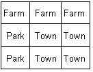
Figure 1 Example Region of
Interest
The area consists of a mixed variety of land-use types in close proximity to a river. The region is divided into a grid, as shown in Figure 1, to help illustrate the spatial variability in the criteria values. To alleviate the flood damage in this region, three potential mitigation alternatives (dyking strategies) are proposed. In each alternative, one of the respective land-use types is completely surrounded by dykes. Two criteria: (a) flood water depth; and (b) flood water velocity, are used for the evaluation of three alternatives. Given a flood of an arbitrary magnitude the flood water depth and velocity for each alternative and land use type are shown in Figures 2 and 3, respectively.
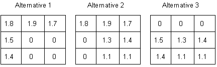
Figure 3: Flood Water
Velocity
Selection
of the best alternative for this example is based on minimizing the flood
water depth and velocity. Using one of the MCDM techniques, (not necessary
due to the problem's simplicity) such as the CP technique, the criteria
values for each alternative would first be averaged across the region of
interest. The average flood water depth for alternatives one, two and three
is 1.22, 1.53 and 1.16 units respectively. The average flood water velocity
for alternatives one, two and three is 0.92, 1.14 and 0.87 units respectively.
Without any additional computations it is obvious that alternative three,
having the least average flood water depth and velocity, would be considered
the best flood mitigation strategy by the CP technique for the region of
interest.
In reviewing the criteria
values shown in Figures 2 and 3 it is apparent that the flood water impacts,
resulting from implementation of each of the three alternatives, are not
evenly distributed across the region of interest. Thus, the selection of
alternative three does not necessarily provide all areas in the region
with the same level of protection. In fact, implementation of this alternative,
as shown by the criteria values, provides only appropriate protection to
the farmland.
2.4. Spatial Compromise Programming
Geographic
information system technologies can be used to include spatial considerations
in MCDM. Past applications of GIS in MCDM have predominantly involved the
determination of the best spatial location for an alternative according
to a predetermined set of criteria (Carver 1991;
Pereira and Duckstein 1993). The research presented here expands the
previous idea to one of determining the best alternative for each spatial
location based on a decision maker's preferences and a set of criteria.
Utilizing the proposed approach can accommodate spatial variation in criteria
values.
A new methodological framework
for spatial decision making is developed by embedding the Compromise Programming
technique within a GIS framework. All aspects of the CP technique are preserved
within the GIS. Preparation of input data for implementation of the CP
technique is done using GIS raster images. All required calculations (Equation
1) are performed within the GIS.
The Spatial Compromise Programming
technique identifies the best solution from a number of alternatives for
each location within the region of interest. As in the application of CP,
the family of distance metrics is the basis on which the alternatives are
evaluated. However, with the SCP technique, rather
than determining a single value per alternative, a distance metric is calculated
for each location (represented by an individual raster cell) in the region
of interest for each alternative. The region of interest encompasses all
geographic locations that are impacted by the combined group of alternatives
and is represented by a raster feature image of the study area.
Criteria values associated
with each of the alternatives are contained within sets of criteria images,
which are geo-referenced with the feature image. Alternatives have their
own individual set of images, and therefore, the total number of criteria
images equals the product of the number of criteria and the number of alternatives.
Each raster cell in a criteria image contains the criteria value associated
with a particular alternative. If the criteria value is spatially variable
then each affected cell, or location, within the image contains a different
value.
Using the criteria images,
and the decision-maker's preferences, a distance metric image is produced
for each alternative. Contained in the distance metric images are distance
metric values for each raster cell calculated using Equation (1).
The algorithmic procedure for producing a distance metric image is shown
in Figure 4. All computations are performed using
GIS commands.
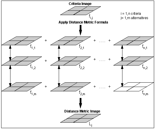
Figure
4 Calculation of Distance Metric Values
in GIS Framework
Using the
values stored in the distance metric images, the best alternative is determined
for each location as one with the smallest distance metric value. A new
image identifying the best alternative for each location is produced with
each cell containing a number corresponding to the best alternative.
Research similar to that
presented in this paper can be found in Pereira and
Duckstein (1993). In the work done by Pereira and Duckstein the CP
technique was applied using GIS technology in order to evaluate the Graham
County region as a potential habitat for the endangered Mount Graham red
squirrel. Each location in the region was evaluated based on a set of criteria
important to the survival of the red squirrel, and was assigned a distance
metric value, as calculated by the CP technique, based on the level to
which each location satisfied the specified criteria. A single distance
metric image was produced for the region, for each tested value of the
parameter p in Equation (1). Each distance
metric image was then discretized into ten habitat quality classes at ordinal
levels by comparing the distance metric values in each cell across each
individual image.
The research presented in
this paper is an extension of the work by Pereira
and Duckstein (1993). The two main contributions of our work are: (a)
replacement of a single distance metric image for the whole region with
a distance metric image for each potential flood protection alternative;
and (b) comparison of distance metric values for each alternative at each
geographic location.
Example Using the example discussed in the previous section, the SCP technique could be used to provide decision-makers with a more detailed evaluation of the three potential alternatives. Required as input for this technique are raster images describing the topography of the case study area, as well as the extent of the potential impacts of each alternative. Figure 1, which shows the land use types in a grid like fashion, represents the raster feature image describing the region of interest. The three sets of flood water depth and velocity values shown in Figures 2 and 3, represent the criteria images for each of the alternatives. Figure 5 is the final best alternative image generated by evaluating the three flood protection measures using the SCP technique.
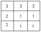
Figure 5 Best
Alternative Image
The
numbers corresponding to the best alternative are contained in each cell
of the image. Thus, the implementation of SCP shows that alternative three,
determined to be the best alternative by Compromise Programming, is not
the best solution for each location in the region of interest.
Using GIS technology the
spatial variability of the criteria values is taken into consideration.
The best alternative for each location in the region of interest is determined
by the application of the SCP technique. The complex decision making process
in the field of water resources can benefit from the additional information
provided by this new technique.
3. Floodplain analysis of the Read River Valley
A floodplain analysis of the Red River Valley has been selected to illustrate the application of the SCP technique. The Red River Valley is located in the south-central portion of the province of Manitoba, Canada. It consists of low-lying flat prairies predominantly used for agricultural purposes. The valley is very prone to flooding and has historically (in 1826, 1950, 1979, and 1996) incurred extensive damages to both urban and agricultural areas from floods. The major floods are typically seasonal in nature, and are the result of combined spring snowmelt and rainfall runoff along both the Red and Assiniboine Rivers (Krenz and Leitch 1993). The 1950 flooding event in Winnipeg was one of the largest natural disasters in Canadian history (Rannie 1980). Water levels in the Red River rose 30.3 feet above datum within the City of Winnipeg (Bumsted 1993). In this flood roughly 640 square miles of cropland were submerged, approximately 10,500 homes were flooded, and 100,000 people had to be evacuated. Roughly 30 million dollars was paid out in flood damages (United States Geological Survey 1952). However, the true cost of the flood may have exceeded 100 million dollars. During this flood communities located upstream of the City of Winnipeg were completely submerged and significant portions of the City of Winnipeg were extensively flooded. Shown in Figure 6 is the extent of the 1950 flood within the City of Winnipeg.

Figure
6 University of Manitoba during the
1950 flood, Winnipeg, Canada
3.2. Existing Flood Protection
To alleviate the damages produced by flooding in the Red River Valley a number of structural and non-structural flood mitigation measures have been implemented over time (Figure 7). These include: (a) a dyking system along both the Red and Assiniboine Rivers; (b) flood pumping stations within the City of Winnipeg; (c) Shellmouth Reservoir; (d) the Portage Diversion; and (e) the Red River Floodway.

Figure
7 Flood Protection System for the City
of Winnipeg and Surrounding Area
It is estimated that the combined measures listed above can provide protection for the City of Winnipeg from river flows up to 169,000 cfs. This magnitude of flooding event corresponds to a predicted return period of approximately 165 years (Rannie 1980). Though this level of flood protection is quite high, the overall flood mitigation strategy for this area requires improvement. Because the protection measures have been developed separately over time, at present they are operated somewhat independently. The level of coordination that does exist requires updating. The optimal efficiency of the existing flood mitigation projects is not currently being attained.
The
focus of the Red River Valley floodplain analysis is a region (7.5 by 5
km) encompassing the community of St. Adolphe along the Red River south
of Winnipeg. The main flood protection for the town of St. Adolphe itself
is provided by a ring dyke, which has an elevation equal to the water level
of the 1950 flood. St. Adolphe is the closest community upstream from the
Red River Floodway inlet and gate structure.
The Red River Floodway,
Manitoba's largest flood protection project, was completed in 1968. The
floodway is a 30 mile long channel, with a flow capacity of 60 000 cfs,
which diverts floodwaters around the east side of the City of Winnipeg
and then reconnects with the Red River near the town of Lockport. The entrance
to the floodway is on the south side of the City, near the community of
St. Adolphe. The flow of water within the Red River is unaffected by the
floodway until the discharge reaches 30,000 cfs. At this flow the water
surface reaches sufficient elevation to permit flow into the floodway.
The flow of water into the floodway channel is controlled by a gate structure
located downstream of the floodway entrance. The gates, which are normally
flush with the bottom of the river, can be raised to produce a backwater
effect that forces water into the floodway channel. The higher the gates
are raised, the greater the backwater and thus the more water forced into
the floodway.
The operations policy of
the floodway is designed in such a way that under normal conditions the
backwater does not alter the upstream water levels compared to natural
water level before construction of the floodway. However, in the case of
a declared state of emergency, in order to save the downstream City of
Winnipeg, flooding of the upstream communities is required (Manitoba
Department of Natural Resources 1984). This decision is typically based
on the economic value of potential flood damage and is a source of conflict
between residents of St. Adolphe and the City of Winnipeg. Therefore, there
is a need for further re-evaluation of the current flood mitigation strategy
for Winnipeg and surrounding area. The technique developed in this research
can be used in re-evaluation of the floodway operating strategy.
The main objective of the
floodplain analysis in this research is to identify the best flood mitigation
strategy, from a set of potential alternatives for the case study area.
A floodplain analysis model is developed for this study. The model is used
to (a) generate a set of potential flood protection alternatives for the
St. Adolphe region, (b) estimate the flood impact, and (c) evaluate and
rank the potential alternatives. Potential protection alternatives are
ranked on the basis of minimizing flood impacts in the St. Adolphe region.
Both, the SCP and the CP techniques are applied in the evaluation process.
3.4. Floodplain Analysis Model
The floodplain analysis model is used to simulate floods for the purpose
of generating flood protection alternatives, as well as to evaluate and
rank the potential alternatives. The floodplain analysis model is comprised
of a GIS and a conventional mathematical model.
Maximum flexibility and
minimum cost in selecting a GIS software led to the selection of the IBM-PC
based package IDRISI (Eastman 1992, 1995).
IDRISI is a raster-based GIS software which delivers a strong analytical
functionality at an affordable cost (Meyer et
al. 1993).
The HEC-2 (United
States Army Corps of Engineers 1982) package is selected to perform
the necessary hydraulic modeling of the floodplain analysis. This model
can be used for estimating water surface elevations for steady or gradually
varied flow in natural or man-made channels. The effects of flow obstructions
such as bridges, culverts and weirs are accounted for in the estimation
of the water surface elevation using HEC-2.
The floodplain analysis
model requires a description of the characteristics of the Red River Valley.
The GIS and HEC-2 databases are used to store all the necessary input information.The
GIS database is comprised of two distinct types of raster images referred
to as feature images and Digital Elevation Models (DEMs). The images are
produced by converting and interpolating data collected by (a) processing
three-dimensional aerial photographs (1:20,000 scale), (b) conventional
land surveying, and (c) digitizing topographic maps. The feature images
identify the two-dimensional locations of both natural and man-made features
in the Red River Valley with respect to the UTM-14N coordinate system.
Each raster cell in the feature images contains a numerical identifier
corresponding to the specific feature located in the coordinate boundaries
of that cell. Fourteen different classes of features are distinguished
in the feature images. An example feature image for the St. Adolphe region
is shown in Figure 8.
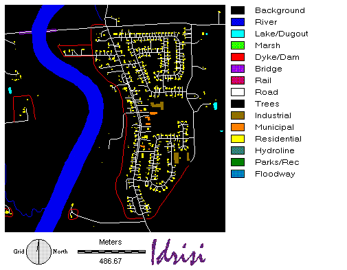
Figure
8 An Example Feature Image of St. Adolphe Region
DEMs
are raster images describing the elevation of the ground surface corresponding
to the same locations and reference system as the feature images. Thus,
for every feature image in the data set there is a corresponding DEM. Each
raster cell in the DEMs contains a number equal to the ground surface elevation
corresponding to the location of that cell.
The HEC-2 model database
is comprised of a specially formatted input file. This file contains a
description of the hydraulic characteristics of the case study area. A
previously prepared HEC-2 input file, already calibrated using the 1979
flood event in the case study area, was conveniently available from the
Manitoba Department of Natural Resources. The majority of the data
in the input file consists of two-dimensional geographic descriptions of
cross-sections of the Red River channel and overbanks. The ground surface
elevations describing each cross-section within the HEC-2 input file are
a subset of the information stored in the DEM portion of the GIS database.
4. Results of the floodplain analysis of the Red River Valley
The floodplain analysis model is first used to generate a set of flood protection alternatives for the case study area. Using the HEC-2 model the Red River water surface elevation is estimated. Using GIS commands and external programs, the water surface elevation is transformed into a raster image identifying the maximum water surface elevation for each location in the region. The GIS component of the floodplain analysis model is then used to determine the actual spatial extent of the flood water by combining the maximum water elevation image, the feature image, and DEM of the St. Adolphe region.
4.1. Flood Protection Alternatives
The original GIS and HEC-2 databases contain a description of the existing
topographic features and flood protection measures of the Red River Valley.
Thus simulating a given flood magnitude using the original data providing
an approximation of the flooding which would actually occur in the St.
Adolphe region. In order to generate new flood protection alternatives
for St. Adolphe, the region's characteristics within the floodplain analysis
model databases need to be modified. These changes should reflect the potential
implementation of new structural or non-structural flood mitigation measures,
or the alteration of existing ones.
A wide variety of flood
protection alternatives could be generated with the floodplain analysis
model. Four flood protection alternatives are generated for the town of
St. Adolphe and surrounding area by combining the following flood protection
measures: (a) construction of small ring dykes around specific areas; (b)
alteration of operation policy for the Red River Floodway; (c) flood proofing
of features having high risk of flood damage; and (d) flood warning for
the community of St. Adolphe and surrounding areas. A description of the
different combinations of previously introduced measures used in each of
the four alternatives for the case study follows.
Alternative 1- Base Case. The first alternative represents the existing state of the flood protection for the town of St. Adolphe and surrounding area. As this community experiences flooding frequently, knowledge of an impending flood can be used to significantly reduce the damage produced by flood waters. For this base alternative, flood warning is provided to the community and surrounding areas. In order to protect the City of Winnipeg, the Red River Floodway operates under the existing operating rule.
Alternative 2 - Protection of Upstream Communities. For better protection of the upstream communities the second alternative includes the lowering of the floodway gates. This results in a water surface elevation decrease of 0.3 m at the floodway entrance. Also, in this alternative all buildings in the study region are flood-proofed to a height of 1 m above the natural ground elevation. Finally, no flood warning is provided to the upstream communities.
Alternative 3 - Protection of the City of Winnipeg. In this alternative the floodway operation is altered to provide better protection for the City of Winnipeg. The height of the floodway gates is changed to increase the water surface elevation at the floodway entrance by 0.3 m. In providing a better level of protection for the city this alternative results in increased upstream flooding. To combat the increased upstream water level, all buildings in the region of interest are flood-proofed to an elevation of 1 m. To further reduce the impacts caused by flood water, the communities are provided with flood warning.
Alternative 4 - Protection of St. Adolphe. For this alternative the entire town is surrounded by a dyke with an elevation significantly greater than the existing topography. For this alternative the floodway is operated normally and all areas within the study region are provided with flood warning.
The floodplain analysis model is used to simulate the effects of the
four proposed protection alternatives. Images showing the flood water extent
given implementation of each alternative are produced. The flood water
extent images are combined with the St. Adolphe feature image in order
to produce a new set of images referred to as flooded feature images, which
identify the locations and features, which are affected by the flood, given
implementation of each alternative. The flooded feature images were used
to determine the flood water impacts that are incurred by the region given
hypothetical implementation of each new flood protection alternative. These
flood water impacts are used as a basis to evaluate and rank the potential
alternatives.
Three different types of
flood water impacts were used as criteria to evaluate the proposed alternatives
using the CP and the SCP techniques. Because SCP is applied using GIS,
the criteria values for each alternative must be in the form of raster
images with each cell containing the magnitude of the impact.
Criteria 1 - Flood Water Depth. The
flood water depth image is prepared using a combination of the flooded
feature image, the water surface elevation as contained in the reach image,
and the DEM. For all flooded locations, the ground surface elevation in
the DEM is subtracted from the calculated water surface elevation resulting
in an image containing the water depth. Flood water depth images are produced
for each flood protection alternative.
Criteria 2 - Building Damage. The second criterion used in the
evaluation of the alternatives is the dollar value of damage to flooded
structures within the region of interest. Three different classes of buildings
(industrial, municipal, and residential) are identified in the feature
image for each region. Damage to each of the buildings is calculated through
application of a stage-damage curve. This curve relates the damage to a
structure as a function of the flood water depth. Stage damage curves for
buildings located in the Red River Valley were developed in 1983 by ECOS
Engineering Services Ltd. The damages indicated by the developed curves
represent average values for all general types of residential buildings
(i.e., bungalow, two-story, etc.) located in this area. The curves relate
the flooded depth of a building to damage incurred as a percent of its
total worth (i.e., structure and contents). However, the flood depth used
to develop the curves includes both flooding to the basement level of the
structure, if one existed, and the depth of water above the ground surface.As
the prepared flood water depth images only contain information on the level
of water above the ground surface, modification to the ECOS stage-damage
curves is necessary. The ECOS curves are modified in such a manner that
the resulting stage-damage curve related above ground flood water depth
to percent damage of the building (see Figure 9).
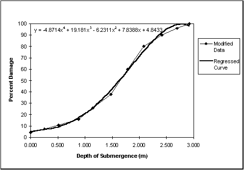
Figure
9 Modified Stage Damage Curve
Using the modified stage-damage curve, an image representing damage
to flooded buildings in the study region was produced for each alternative.
The estimated value for the residential, municipal, and industrial building
classes used in this study was $50,000, $100, 000, and $200,000, respectively.
Criteria 3 - Benefit from Flooding Upstream Areas. The final
criterion used in the evaluation of the alternatives is a measure of the
benefit from flooding the upstream communities. In the case study region,
upstream communities, such as St. Adolphe, often experience increased flooding
due to the floodway operation aimed at reducing damages to the City of
Winnipeg. Thus, from an economic standpoint it is suggested that there
is a benefit associated with flooding the upstream areas. The more water
that is stored further away from Winnipeg, by flooding the upstream areas,
the greater the benefit, or reduction in downstream damages.
The magnitude of this benefit
is a function of the volume of water stored upstream, and the distance
of the stored water from the City of Winnipeg. The amount of water stored
upstream resulting from the implementation of each alternative is shown
in the flood water depth criteria image. Each raster cell of this image
contains a value, which corresponds to the water depth for that particular
geographic location. Thus, the volume of water in each location is known.
The distance of each raster cell from the City of Winnipeg can be determined
using GIS commands. The magnitude of the benefit associated with flooding
upstream areas is calculated by multiplying the flood water depth in each
raster cell with its proportional distance from the City of Winnipeg. In
other words, given two cells flooded to an equal elevation, the one closer
to the city would produce a lower benefit than one located further away.
An image identifying the benefit of flooding different locations in the
study region is produced for each alternative.
4.3. Evaluation of Flood Control Alternatives
The four proposed flood protection alternatives are evaluated on the
basis of the three criteria discussed above. Both, the CP and the SCP techniques
are used to evaluate the alternatives. The CP technique is used to identify
the best flood protection alternative for the region as a whole. Using
the SCP technique the best alternative is determined for each location
in the St. Adolphe region. The latter approach allows consideration of
local impacts produced by flooding. By identifying the best alternative
for each geographic location, potential sources of conflict between upstream
and downstream communities arising from the implementation of different
alternatives are made apparent.
Weights indicating the relative
preferences of decision makers towards the criteria and the importance
of their maximal deviation from the ideal solution are necessary input
for both CP and SCP techniques. The importance of the deviation of solution
from the ideal value is reflected by the value of p in Equation
(1). In this study, a single value of p
= 2 (a straight line, shortest distance metric) is used following the recommendations
from the literature (Simonovic 1989). The decision
makers' preferences are represented by wi in Equation
(1). In this case study three different sets of weights are selected (Table
1) to address the potential different preferences of the various interest
groups.
Table 1 Decision Makers' Preferences
|
|
|
||
|
|
|
|
|
|
|
|
|
|
|
|
|
|
|
|
|
|
|
|
In all three sets of weights,
the highest priority is given to the criteria measuring damage to submerged
structures. Usually in multi-criteria analyses, one option indicating equal
importance of all criteria is considered. However, due to the importance
of the building damage criteria, an option with equal weights is not included
in this study.
With regards to the two
remaining criteria, in the first set of weights they are assigned an equal
level of importance. The other two sets of weights attempted to capture
the differences in interests of the upstream (set #3) and downstream communities
(set #2).
4.4. Compromise Programming Analysis
The CP technique is first implemented to identify the most acceptable alternative for the whole region. As CP does not account for spatial variation of the criteria values, the values contained within the criteria images had to be converted into a format, which could be used with this technique. A single number representing the impacts produced by each flood protection alternative is calculated for each of the three criteria. The flood water depth and flooding benefit are averaged across the region, while the damage to all classes of buildings in the region is totaled. The results are shown in Table 2.
Table 2 Spatially Invariable Criteria Values
| Alternative |
|
||
|
|
|
(m4) |
|
|
|
|
|
|
|
|
|
|
|
|
|
|
|
|
|
|
|
|
|
The
final results of the evaluation using CP and input from Tables
1 and 2 are shown in Table
3. Alternative four is determined to be the most appropriate flood
protection strategy for the St. Adolphe region for all different weight
combinations.
Table 3 Results of the Compromise Programming Analysis
|
|
|
|
|
|||
|
|
|
|
|
|
|
|
|
|
|
|
|
|
|
|
|
|
|
|
|
|
|
|
|
|
|
|
|
|
|
|
|
|
|
|
|
|
|
|
4.5. Spatial Compromise Programming Analysis
SPA is capable of addressing the spatial variation in criteria values.
Using the criteria images and the weights from Table 1, each of the four
potential flood protection alternatives is evaluated with the SCP technique.
The first evaluation step involves the development of a distance metric
image for each alternative. The resulting images contain a distance metric
value in each raster cell that corresponds to the relative impact produced
by each alternative. The best alternative for each location is identified
by comparing the distance metric values corresponding to the four potential
alternatives. An image identifying the most acceptable alternative for
each location in the region is produced for each set of decision-maker
preferences (Figures 10, 11,
and 12).
The difference in the images
in Figures 10, 11 , and
12,
indicates the significant effect of the decision-makers' preferences on
the outcome of the evaluation. A number of general observations regarding
the effectiveness of the potential flood protection alternatives for various
locations in the region of interest can be made. In each of the three sets
of the decision-makers' preferences, alternative one generally proves to
be the most acceptable for building locations outside of the town of St.
Adolphe. Since alternative four provides a complete protection of St. Adolphe,
it is the most acceptable flood protection strategy for locations within
the town. Alternative three is generally ineffective as a mitigation strategy.
Many locations in the study region, in and outside of the town of St. Adolphe,
consist predominantly of uninhabited areas or farmland. The most appropriate
protection alternative for these areas changes frequently with the decision-makers'
preferences. For weight set #1 the predominant choice is alternative 2
(Figure 10).

Figure
10 Best Alternative Image for Weight
Set #1
The
second set of weights represents the interests of the downstream region.
The evaluation of the potential flood protection strategies would favor
alternatives that store a larger volume of water upstream of the Red River
Floodway. The effect of this set of decision-makers' preferences is shown
in Figure 11. Alternatives one and four are selected
as best for locations in which alternative two was previously selected
as the most appropriate using the first set of weights. This is logical
because alternatives one and four correspond to a slightly greater overall
depth of flood waters in the St. Adolphe region.

Figure
11 Best Alternative Image for Weight Set #2
The final set of weights used in the evaluation of the potential flood protection alternatives places a greater emphasis on minimizing the flood water depth, in contrast to the benefits associated with flooding the region of interest. This set of weights represents the decision-makers' preferences in protecting upstream communities. In this case the alternatives selected as the most appropriate for the study region are those that minimize the overall upstream volume, or depth, of flood water. For almost all locations within the town of St. Adolphe, as shown in Figure 12, alternative four is selected as the most appropriate. This is expected since the ring dyke used in this alternative is constructed to eliminate flooding in the community. For uninhabited areas outside St. Adolphe, because alternative two offers the lowest overall flood water depth, it is predominantly selected as the most appropriate.

Figure
12 Best Alternative Image for Weight
Set #3
Water resources analyses require use of spatially distributed information.
GIS technologies are an effective tool for storing, processing, managing,
and analyzing spatial information. Two practical applications of a GIS
in the field of water resources are illustrated in this paper: (a) the
use of a GIS for floodplain analysis; and (b) the use of a GIS in water
resources multi-criteria decision-making.
The main contribution of
the work presented in this paper is the introduction of an original MCDM
technique named Spatial Compromise Programming, developed by embedding
the conventional Compromise Programming technique within a GIS framework.
Both CP and SCP are used
to evaluate the potential flood protection alternatives for a portion of
the Red River Valley, Manitoba, Canada. The use of conventional CP results
in alternative four being selected as the most appropriate for all sets
of decision-maker preferences. However, the SCP technique shows that this
strategy may not necessarily be the best for all locations in the study
region. By maintaining the spatial variability of the criteria values,
localized impacts associated with each alternative are taken in consideration
with the application of the SCP technique. The technique is used to determine
the best flood protection for each distinct location in the St. Adolphe
region. It is shown that alternative four, selected as the best by CP,
is not necessarily the best alternative for all areas in the region. It
is also demonstrated that the choice of the best alternative for many locations
is very sensitive to the decision-makers' preferences.
Local impacts produced by
different alternatives are addressed through the use of the SCP technique.
This is accomplished by maintaining the spatial variability of the criteria
values in the evaluation of the alternatives. Application of the SCP technique
provides decision-makers with additional information important in water
resources decision making. We hope that this will lead to better and more
efficient decision making in the field of water resources.
Banai, R. (1993) Fuzziness in Geographical Information Systems: contributions from the analytic hierarchy process, International Journal of Geographical Information Systems, 7, 315-329.
Bose, D. and Bose, B. (1995) Evaluation of Alternatives for a Water Project Using a Multiobjective Decision Matrix, Water International, 20, 169-175.
Bumsted, J. M. (1993) The Manitoba Flood of 1950 - An Illustrated History. Canada: Watson and Dwyer Publishers.
Carver, S.J. (1991) Integrating multi-criteria evaluation with geographical information systems, International Journal of Geographical Information Systems, 5, 321-339.
Duckstein, L. and Opricovic, S. (1980) Multi-objective optimization in river basin development, Water Resources Research, 16, 14-20.
Eastman, J.R. (1992) IDRISI Geographic Information System, version 4.0. Clark University: Graduate School of Geography.
Eastman, J.R. (1995) IDRISI Geographic Information System, version 1.0 for Windows. Clark University: Graduate School of Geography.
ECOS Engineering Services Ltd. (1983) Development of depth-damage curves for residential and farm structures in southern Manitoba - Report to Environment Canada. Regina: Inland Water Directorate.
Fedra, K. (1997) Spatial Decision Support in Resources Management and Environmental Applications, Proceedings of the Eleventh Annual Symposium on Geographic Information Systems held in Vancouver, British Columbia, Canada, 302-305.
Fürst, J., Girstmair, G., and Nachtnebel, H.P. (1993) Application
of GIS in Decision Support Systems for Groundwater Management. In "HydroGIS93:
Application of Geographic Information Systems in Hydrology and Water Resources"
edited by K. Kovar and H.P.
Nachtnebel, IAHS Publ. no. 211, pp. 13-21.
Gershon, M., Duckstein, L., and McAniff, R. (1982) Multiobjective River Basin Planning With Qualitative Criteria, Water Resources Research, 18, 193-202.
Goicoechea, A., Hansen, D.R., and Duckstein, L. (1982) Multiobjective Decision Analysis with Engineering and Business Applications. New York: John Wiley & Sons.
Hobbs, B.F., Chankong V., Hamadeh, W. and Stakhiv, E.Z. (1992) Does Choice of Multicriteria Method Matter? An Experiment in Water Resources Planning, Water Resources Research, 28, 1767-1779.
Krenz, G. and Leitch, J. (1993) A River Runs North - Managing an International River. Manitoba: Red River Water Resources Council.
Leipnik, M.R., Kemp, K. K., and Loaiciga, H. A. (1993) Implementation of GIS for Water Resources Planning and Management, ASCE Journal of Water Resources Planning and Management, 119, 184-205.
Manitoba Department of Natural Resources (1984) Red River Floodway Program of Operation. Manitoba: Water Resources Branch.
McKinney D. C. and Maidment, D. R. (1993) Expert Geographic Information System for Texas Water Planning, ASCE Journal of Water Resources Planning and Management, 119, 170-183.
Meyer, S. P., Salem T.H., and Labadie, J. W. (1993) Geographic Information Systems in Urban Storm-Water Management, ASCE Journal of Water Resources Planning and Management,119, 206-227.
Pereira, J.M.C., and Duckstein, L. (1993) A multiple criteria decision-making approach to GIS-based land suitability evaluation, International Journal of Geographical Information Systems, 7, 407-424.
Rannie, W.F. (1980) The Red River Flood Control System and Recent Flood Events, ASCE Water Resources Bulletin, 16, 207-214.
Shafike N.G., Duckstein L., and Maddock III, T. (1992) Multicriterion Analysis of Groundwater Contamination Management, AWRA Water Resources Bulletin, 26, 33-43.
Simonovic, S.P. (1989) Application of Water Resources Systems Concept to the Formulation of a Water Master Plan, Water International, 14, 37-50.
Simonovic, S.P. (1993) Flood Control Management by Intergrating GIS with Expert Systems: Winnipeg City case study. In "HydroGIS93: Application of Geographic Information Systems in Hydrology and Water Resources" edited by K. Kovar and H.P. Nachtnebel, IAHS Publ. no. 211, pp. 61-72.
Tim, U.S. (1997) Integrated Spatial Technologies for Non-point Source Pollution Control and Environmental Management, Proceedings of the Eleventh Annual Symposium on Geographic Information Systems held in Vancouver, British Columbia, Canada, 143-149.
United States Army Corps of Engineers (1982) HEC-2 Water Surface Profiles Users Manual. Davis, California: Hydraulic Engineering Center.
United States Geological Survey (1952) Floods of 1950 in the Red River of the North and Winnipeg River Basins, Water Supply Paper 1137-B, Water Resources Division, Department of the Interior.
Walsh, M.R. (1993) Toward Spatial Decision Support Systems in Water Resources, ASCE Journal of Water Resources Planning and Management, 119, 158-169.
Watkins, D.W., McKinney, D.C., Maidment, D.R. and Lin, M.D. (1996) Use of Geographic Information Systems in Ground-Water Flow Modeling, ASCE Journal of Water Resources Planning and Management, 122, 88-96.
Wolfe, D.S. (1997) Integrated Resources Management Using Spatial Allocation: A Case Study, Proceedings of the Eleventh Annual Symposium on Geographic Information Systems held in Vancouver, British Columbia, Canada, 424-427.
Zeleny, M. (1973). Compromise Programming-Multiple Criteria
Decision Making, Columbia: University of South Carolina Press.

