
Jeffrey M. Keisler
Strategic Decisions Group, Two
International Place, 20th Floor, Boston, MA 02110-4101, USA
keisler@anl.gov
Ronald C. Sundell
Center for Environmental Restoration
Systems, Energy Systems Division, Argonne National Laboratory, Argonne,
Illinois, 60439, USA
ron_sundell@qmgate.anl.gov
KEYWORDS: Decision analysis, multi-attribute utility, geographic information system, spatial analysis, park, boundary.
The quality and value of a park or protected area depend on what is found within its designated boundaries. We have integrated multi-attribute utility theory (MAUT) with spatial analysis so that the value of a park can be measured in terms of its boundaries; this method can be used to determine desirable boundaries. To explain the approach, some background information on MAUT has been provided. This is followed by a discussion of how to combine MAUT with geographic information systems (GISs) in the form of a geographic multi-attribute utility system (GMAUS). Finally, this concept is applied to make decisions about park boundaries.
1.1
Park Boundary Decisions
What is meant by a park boundary decision? In general, there must be
a decision-making body with preferences over outcomes; otherwise, it does
not matter what is done. Also, there must be different actions that the
decision maker can take that may affect the status of the region, or else
there is no decision to be made. Finally, there must be some model to show
how actions affect outcomes, otherwise there is no information on which
to base the decision.
In considering a single,
canonical park-boundary decision, assume that (1) there is a region, (2)
lines can be drawn that define what parts of that region are inside park
boundaries, and (3) the value of the park is determined. In order to develop
rational and by efficient plans, decision makers must make trade-offs among
multiple objectives and balance objectives among different border configurations.
Many objectives are not easily compared as they are not naturally expressed
in comparable terms. At the same time, there may be idiosyncratic objectives,
the importance of which depends on the context (e.g., the value of the
whole may be more or less than the sum of its parts). Some objectives are
of decreasing marginal importance after reaching a certain level, while
others may have no value until a certain level is attained. Different people
will consider different objectives to be important, and some objectives
deemed to be important may not be easily met by park management policies
and directives.
Given all these complexities,
it might be possible to identify small changes in park boundaries that
are clearly beneficial. However, it is almost impossible to look at a large
area and simply decide what it should look like, nor is it possible to
look at a sheet of statistics about an area and decide what should be done
to further the goals of society or of the park service. In fact, it is
difficult even to hold a discussion about whether planned changes are good
or bad without degenerating into argument and confusion. The framework
in this paper can be used to clarify discussions and planning considerations.
1.2
A Mathematical Statement of the Problem
We assume that the value of an area is determined by its boundaries
(e.g., what regions are in national parks, what regions are in national
forest, etc.). We define the boundaries of an area as a partition p
Î P, and
P = {(a1, ...
, an) | ai
Î R2,Èi(ai
)
= A, Çi
(ai
)
= Æ},
where A is the area under consideration.
First, we consider a special
case of the general problem, where n = 2, which corresponds to areas inside
and outside the park. The value or "utility" of the area with a given set
of boundaries (which we will discuss in more detail shortly) is denoted
as
U(p): P ® R .
Some potential boundaries may not be feasible (e.g., too expensive,
too complex, etc.) Denoting the set of allowable partitions by P*, the
decision problem can now be stated as finding
MAXP {U(p) | p
Î
P*}.
Defining the function U(*) in a usable and useful
manner is difficult, because there is no obvious connection between the
lines on a map and societal value. This task can be simplified by breaking
it into two subtasks: (1) develop a set of n measures, x, derived from
the map with the proposed partition, x : P ®Rn
, and (2) define a function, U(x): Rn®
R,
that operates on the measures.
2. A Multi-Attribute Utility Theory Approach
Prior state-of-the-art decision-making tools consisted of two major approaches: suitability indices and site evaluation. Because the approach used in this paper attempts to combine the best features of both, these two approaches are reviewed before the proposed approach is presented and discussed.
2.1
Additive Suitability Indices
Decision makers use the approach of additive suitability indices (Sundell
1991) to develop measures and to rate cells (small square regions on
a map) with respect to those measures (e.g., suitability for natural habitat
for particular species, recreation, historical value, or other uses).
A score is generated for each cell on the basis of its suitability indices;
cells above a certain threshold score may be defined as critical resource
areas. A typical (though simple) suitability index, for example,
is the quality of a particular cell (the smallest area differentiated within
GIS data) as a habitat for a given species, such as the prairie chicken:
· Poor if there is no cover and no food.
· Medium if there is cover, but no food.
· Excellent if there are both cover
and food.
In this example, cover is defined as an area of more than 65 ha of
contiguous fair or good (native/late successional) grassland, and food
is defined as areas within 600 m of a (man-made) food plot. This
definition is fairly straightforward to implement in a GIS. Of course,
land planning usually encompasses many parameters, not just a single habitat.
Sundell shows how to determine an overall critical resource index by assigning
to each cell a weighted sum of scores on a range of suitability indices.
Suitability indices are used with a GIS to measure the important considerations
in land management. Specific critical resource indices, (e.g., critical
biodiversity resource, critical archaeological resource, critical economic
resource) are also used.
A decision support system
(DSS) based on this approach assigns cells to different uses, depending
on their critical resource scores and their relation to certain threshold
values. For example, a DSS might recommend that any cell with a biodiversity
score above 75 (on a scale from 0 to 100) be set aside as a preserve.
This approach has several strengths. It allows the computer to process
large amounts of data, yet provides for human input where expertise about
natural processes and value judgments are needed. In a complex environment,
this flexibility is not just a matter of convenience; it might be impossible
for decision makers to recognize intuitively whether an area meets certain
scientific requirements, especially when every square meter must be considered.
A DSS also allows any number of considerations to be included, through
separate input from experts on separate issues.
A DSS can be extremely informative
to a planner, and for continuous decision variables (e.g., how far to expand
a park in different directions), it serves as an appropriate starting point
for a more thorough defined process for making decisions. However,
the approach is not very useful for making explicit trade-offs. In
some cases, there is diminishing marginal value to assigning land to a
particular use; for example, the recreational value of observing 100 waterfalls
might not be much more than the recreational value of viewing only 10 waterfalls
to some park users. In other cases, a certain threshold must
be reached before there is any value to assigning land to a use.
For example, since 50 ha of good wolf habitat is not enough to sustain
a pair of wolves, it has no value in terms of protecting the species, while
1000 ha might be of significant value (i.e., 20 times as much land has
more than 20 times the value). Threshold values may apply to fragmented
areas or to a whole site. Another problem is that the same land area
cannot be assigned simultaneously to all of the uses for which it has potential,
and so its overall value is not simply the sum of its suitability value
for different purposes.
In summary, the suitability
index approach essentially defines a function x(p), where the components
of the vector x are the numbers of cells containing each critical resource
within the different areas defined by p. However, the major deficiency
in this approach is that it does not assign an explicit value to a set
of boundaries (i.e., it does not utilize a function like U(p)).
2.2
Site Evaluation
This approach is used to develop measures for evaluating sites ranging
in size from a specific point, to a linear feature, and to a large area.
A good example is the value model described by Jankowski
and Richard (1994) for siting a water transmission line, on the basis
of cost, right-of-way acres, daily traffic on roads, erosion hazard acres,
seismic hazard areas, area of wetlands, and the length of stream segments
falling within the right-of-way. A linear weighting of these scores
is used to generate a total score for each of several proposed areas (sites).
Site evaluation uses a mix
of objective measures (which may or may not be computer generated) and
subjective measures. The site evaluation approach has been
used largely for deciding where to build things and, has not been used
explicitly in park boundary delineation. In this approach,
a multi-attribute utility function is used to describe the attractiveness
of a site. For example, a planned nuclear waste facility could be
sited (Keeney and von Winterfieldt 1994) in Nevada,
South Carolina, or Washington, among other places. The attractiveness
of a site is a function of its distance from population centers, proximity
to existing sources of waste, capacity, political fairness, and susceptibility
to earthquakes. The scales are defined in detail, often in terms
of geographic features. Because the scales are defined in a hierarchical
manner, starting with decision makers fundamental needs, they reflect
decision-maker preferences well, including non-linearity, the interactions
between objectives, and considerations that are more social rather than
spatial in nature.
This approach, however,
has limitations with respect to making decisions about park boundaries.
The main limitation is that it is labor-intensive. Separate subjective
input for each evaluation can be costly and time-consuming when innumerable
alternatives must be evaluated. Also, many subjective values may
be difficult to measure precisely (e.g., minimize damage, maximize water
quality, minimize fragmentation, minimize feral species, etc.). Although
an expert might be able to look around and give a subjective score for
each attribute, better definitions would make this process more time-consuming.
This approach defines the function U(x), however x(p) is not explicitly
defined. Instead, a planner must supply subjective measures.
2.3 Proposed Approach
Researchers have applied the MAUT approach to numerous environmental
and planning problems. Our approach is similar to the above approaches,
but integrates them in a two important ways. First, it starts with
the definition of the decision makers fundamental objectives and works
backwards to define useful measures that can be derived from available
data. It must be possible to obtain these measures, or the utility function
is not practical. Second, measures are related back to an overall
score for the site through a structure that includes nonlinear relationships
and interactions among terms, rather than with linear weights, thereby
accounting for such factors as risk and diminishing marginal benefits.
The result is a score that, if correctly constructed, should correspond
perfectly to decision-maker preferences (i.e., U[x(p1)]
> U[x(p2)] if, and only if, the decision
maker prefers p1 to p2
for all p in P). This last condition is the acid test for a rule
to score alternatives. Although simpler approaches can be useful
for decision support, they are unlikely to pass this test.
A good multi-attribute utility
function (MAUF) will improve decision making by speeding the identification
of the most attractive alternatives. When making intuitive comparisons
is difficult because there are many factors in play at once, a multi-attribute
utility function provides the summary information necessary to sort out
the best alternatives. By separating the process of thinking about
values from thinking about the specific attributes of a proposed set of
boundaries, there is a better chance of having logical consistency in a
comparison of alternatives. People are the source of the value judgments,
but calculations about those judgments are fallible, especially when they
rely on huge amounts of data and multiple dimensions. In these areas,
a MAUT-based decision-support system helps a planner (or a society), who
cares about certain objectives to achieve those objectives to a greater
extent.
The proposed approach is
to take the front-end provided by site evaluation and attach it to the
back-end provided by suitability indices. With this approach, a hierarchical
MAUF can be constructed with measures that are based on the same type of
map layers as used for suitability indices. This approach requires
an iterative process, in which important decision attributes are repeatedly
compared to proxy measures derived from available information. Attributes
and measures are refined (it is possible to have different representations
of the value function) until a sufficient and complete set of measures
and a corresponding value function are defined.
From raw data (input map
layers), thematic map layers can be derived that consist of suitability
indices for individual cells. Descriptive statistics from these thematic
maps can then be generated. A number of techniques adapted from decision
analysis and spatial analysis make it possible to have quite rich measures,
as described below. The objectives hierarchy is then modified so
that it is completely supported by these statistics as measures.
In our experience, this requires both a high level of effort in developing
definitions and several meetings between actual decision makers and the
developers of the DSS. At this point, an MAUF can be assessed in
the usual way. First, a single attribute utility function (SAUF)
is defined over varied attribute levels (where the attributes are chosen
for ease of assessment, so long as their relationship to the measures is
unambiguous). Then an MAUF is defined in terms of the SAUFs.
The term GMAUS (Geographic Multi-Attribute Utility System) describes a
system that would implement U[x(p)], which would consist of geographic
and spatial analysis for identifying x(p) and a compatible utility function.
2.4 Methodology
Applying an MAUF to GIS-based problems presents some new methodological
issues, which will be described in Section 3, along with the standard steps
of a decision analysis. The steps involved are as follows:
(i) Develop an objectives hierarchy, including
Fundamental objectives (what is really important)
Operational (means) objectives
Indicators that would be used in a multi-attribute utility
function if there were no GIS
(ii) Define maps that will generate measures (critical resource variables)
and relate them to indicators.
(iii) Quantify the utility function for the attributes in terms derived
from measures; this effort entails defining minimum and maximum values
for each attribute, the shape of SAUFs, the constructive and destructive
interactions between them (Smith 1994), and weights.
3. How Can This Work for Park Boundary Decisions ?
In this section, the use of a multi-attribute utility study is described for considering modifications to a single parks boundaries. This prototypical analysis has not been executed but is based on experiences with natural resource land managers at Glacier National Park and at several military installations (although the goals and objectives may be substantially different for these two types of managers, the basic decision analysis process is similar).
3.1
Defining Objectives and Measures
First, a decision maker must be identified (or other affected parties)
whose values need to be incorporated in the utility function. For
present purposes, assume that (1) the decision maker is a park manager
and (2) the park system operates with a single set of values. Although
this is not exactly the case, values are much more likely to be consistent
within a single organization than across groups. Other groups are
likely to have objectives that overlap with park service objectives, but
with different relative weights attached to the objectives.
Once the appropriate people
are identified, they are consulted. First a brainstorming session
is undertaken to identify all the objectives that these decision makers
may want to achieve. These objectives must be defined explicitly,
with a direction attached (e.g., maximize the preservation of archaeological
sites). Next, the objectives are arranged in a loosely hierarchical
structure. At one end are fundamental objectives for the context,
which are the things desirable for their intrinsic value (e.g., preserving
beauty); a stylized example is shown in Figure 1.
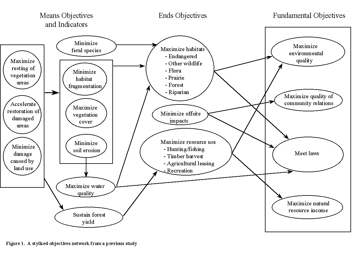
Figure
1 A stylized objectives network from a previous study
There may also be objectives
that are partially outside the context of a given situation, (e.g., maximizing
global biodiversity might be important), that are not completely under
the control of any single agency or nation. For a park service, contributions
to world biodiversity needs and establishing significant biodiversity within
national borders may be separate objectives. However, the value of
local actions still must be considered in light of global needs (e.g.,
park land that serves as habitat for a globally threatened species might
be more important to protect than if the species were threatened only locally).
Returning to Figure
1, to the left of fundamental objectives are ends objectives
desirable because they are integral to fundamental objectives.
For example, preserving forests is a part of preserving beauty. To
the left of these are means objectives and indicators characteristics
which are desirable because they lead to the end objectives, but which
would not be important if something else accomplished the same ends.
An example of a means objective is minimizing the acidity of rain, which
is desirable because it affects the quality of flora and fauna. At
the left end of the structure are measures, indicators, or proxies elements
whose presence is a sign that other desirable elements have occurred.
For example, the presence of an indicator species would indicate that the
whole ecosystem is still functioning in the desired manner.
For land-management problems,
there are usually two fundamental objectives to consider: use value and
conservation value. For Glacier National Park, conservation value
has two components: natural conservation and cultural conservation.
Use value has a number of components, some of which are positive (education,
recreation, etc.), and some of which are the extent to which negative consequences
are averted (safety, carrying capacity). These objectives sound as
if they would be difficult to measure, and even more difficult to assign
trade-offs, but by adding one more level to the hierarchy of objectives,
it can be done. Cultural resources include archaeological, architectural,
historical, recreational, and religious sites.
Once objectives have been
defined to the point at which they are explicit, unambiguous, and complete
(i.e., nothing important is left out), measures are defined. Defining
the objectives hierarchy and the measures are interrelated tasks.
Not every objective needs to measured explicitly; but at some point, every
fundamental objective must either be assigned a measure or defined explicitly
in terms of something else that is assigned a measure (i.e., no loose ends).
Identifying suitable measures
for use with a GIS requires some thought about what quantifiable proxies
for these measures might be captured in electronic form. The process
of identifying measures is described well in Keeney
(1992). The examples in this article illustrate how the set
of useful measures and the set of measures that are obtainable electronically
measures can be expanded to the point where their intersection contains
complete electronically obtainable measures for each fundamental objective.
The sites of each type included within proposed boundaries are already
marked on existing maps so the numbers of these sites are convenient measures.
Assuming the map layers are in electronic form, the measures can be an
output automatically generated from input data consisting of the proposed
boundary decisions and the existing maps. It is important to use definitions
that are as precise as possible, although definitions can always be refined
as the utility function is developed.
3.2
Quantifying Values and Trade-Offs
Once the objectives and measures have been defined, values and trade-offs
can be quantified. Quantifying values and trade-offs can be emotionally
difficult for participants because it requires soul searching on issues
about which people may care deeply but have not given considerable thought
to their value (e.g., the simple fact that for some creatures to live,
others must die). However, because this part of the process brings
new data (about decision maker values), it often makes the biggest difference
in the quality of the decision.
To quantify value (Keeney
and Raiffa 1976; Keeney 1992), SAUFs must first be defined. For
each measure, a range with a minimum and a maximum for the values the measure
may take over the set of potential decisions must be identified.
Then the way these measures relate to the fundamental objectives must be
defined explicitly (e.g., the measure of cultural conservation value can
be defined as a function of the numbers of several types of sites).
For example, a raw score for cultural conservation value could be 20 times
the number of archaeological sites plus 0.5 times the number of architectural
sites. This score will then be transformed to a score between 0 and
1. In this range, the relationship can be assigned so that a change
from a score of 0 to 0.5 is valued as much as a change from 0.5 to 1.
This is accomplished by determining its minimum value and assigning 0 to
this value; 1 is assigned to the maximum value. The decision maker
decides what the score is at the midpoint between 0 and 1. Thus, a SAUF
has been defined in terms of its measures.
Once SAUFs have been constructed for all our fundamental
objectives (ideally objectives between which there are no interactions),
they can be combined to form a multi-attribute utility function by assigning
weights (which sum to 1) to all SAUFs. The result looks like
the following:
U(x) = S wi
wij uij[f(x)],
(1)
where the subscript, ij, refers to the i-th attribute and
the j-th sub-attribute.
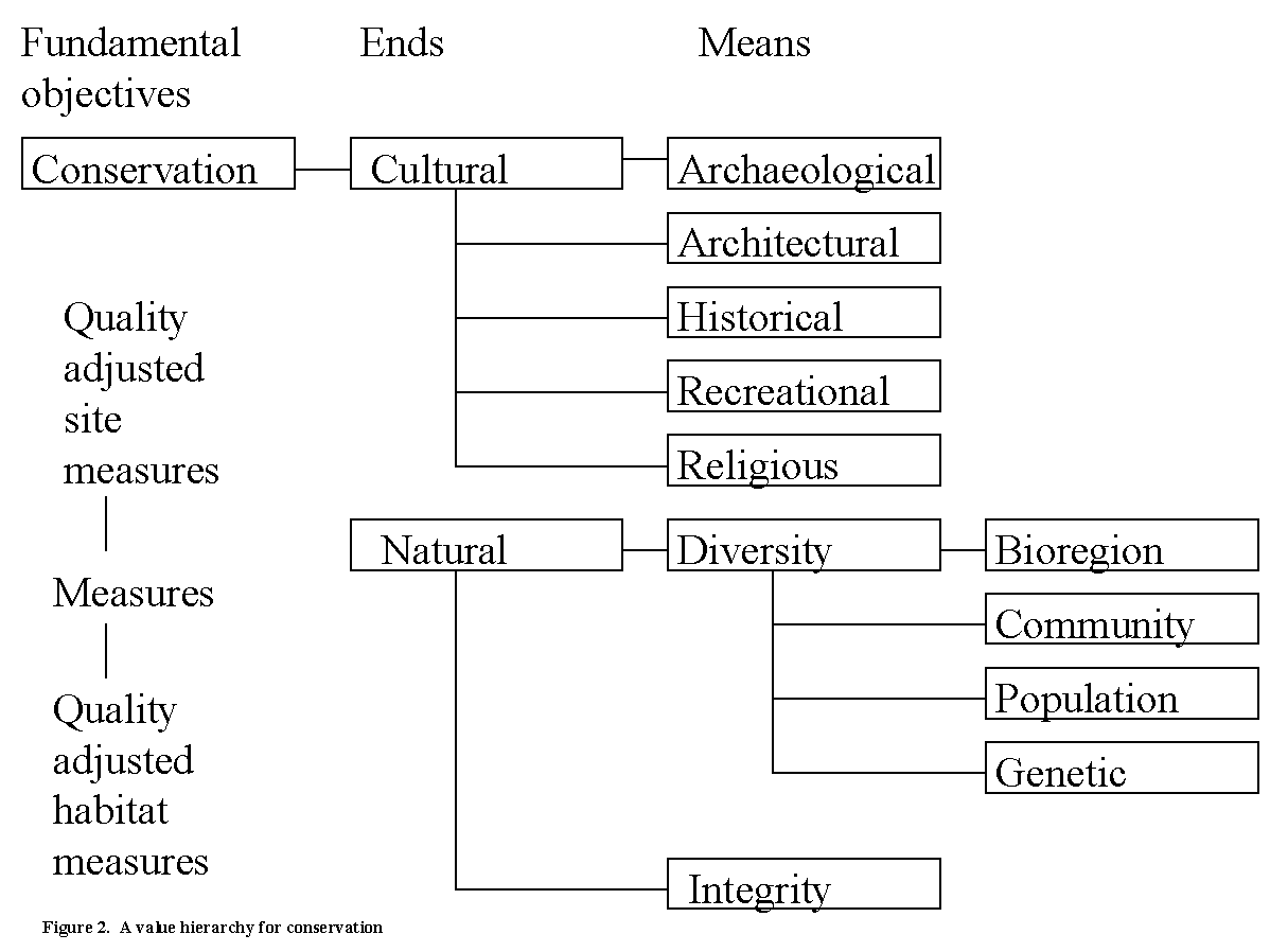
Figure
2 A value hierarchy for conservation
To illustrate, a hypothetical
utility function can be constructed and compared to two hypothetical alternatives.
This utility function is an outgrowth of the function developed by the
Argonne National Laboratory for the purpose of natural resource management
at Fort Riley, Kansas (Sundell et all, in preparation). Starting
with the conservation objectives hierarchy shown in Figure
2 (which is only one of the three pillars of the complete objectives
hierarchy), the archaeological measures could be defined as the number
of quality-adjusted sites within protected boundaries (not necessarily
the park itself), where the quality of the site is subjectively estimated
and recorded on a map (this must be done for each site) and the adjustment
factors are:
· Low importance = 0.2
· Medium importance = 0.4
· High importance = 1.0
The definition of the quality
adjustment for a site uses a constructed scale, for which the meaning of
low importance would have to be verbally described, unless unambiguous
or quantitative data are already available. The classification of
an individual site would necessarily be subjective. This scale is
used to translate qualitative measures into quantitative measures, over
which we define a SAUF. The SAUF is defined in terms of the number
of quality-adjusted sites. First, the range of possible values is
identified as follows:
· Minimum = 0.6, because there is one low-importance site
and one medium-importance site that will be within protected boundaries
no matter what.
· Maximum = 4.0, because there are no other sites in the
region under consideration.
3.3
Single Attribute Utility Functions for Social/Cultural, Conservation, and
Consumptive Values
Numbers can now be attached to the hierarchical value structure in
Figure
2 to generate SAUFs for park boundary decisions. The purpose
of this exercise is twofold. First, much of the basic structure identified
and many of the attributes defined are applicable over a wide range of
park boundary decisions, so this structure can serve as a template to be
modified as needed for many types of decisions. Second, the interaction
between the attributes of concern and the measures defined for them is
very interesting; a variety of qualitatively different measures to illustrate
some of the numerous techniques used in quantifying values are included.
The precise structure and the numbers used here are merely illustrative,
although several are inspired by our experience interacting with natural
resource planners and decision makers. For brevity, and because the
results are not for an actual decision, not all attributes and SAUFs are
defined here.
First, all SAUFs will be normalized so they are 0 when the attribute
is at its minimum value and 1 when the attribute is at its maximum.
Next, the shape of the SAUF between 0 and 1 will be defined. A fairly
easy way to do this is by finding the "value midpoint," where the incremental
value of moving from the minimum value to the midpoint is the same as the
incremental value of moving from the midpoint to the maximum value.
An exponential curve can be fit to the three available points, i.e.,
U(W) = (1 - ekw)/(1- ek)
(2)
where k is such that U(W) = 0.5. W is the normalized midpoint
found from the equation for the attribute. W = (midpoint value -
minimum value/maximum value - minimum value).
The attributes from the
basic structure shown in Figure 2 serve as examples.
Three major types of uses are described here and are grouped by:
(1) social/cultural, (2) conservation, and (3) consumptive values.
Social/Cultural Values The first major objective to be considered is how well the park serves as an asset for human society. The attributes considered here tend to be discrete, the measures fairly obvious (i.e., number of sites), and the tradeoffs between them based on necessarily subjective judgments.
(i) Attribute: Historical Sites
Measure: Quality adjusted number of sites located within protected
boundaries.
Suitability Index Scale:
Low = 0.1 (location where significant event occurred; e.g., a deserted
battlefield)
Medium = 0.4 (location of an event, including generic artifacts;
e.g., houses
standing from the time of the event)
High = 1.0 (location of event with intact artifacts from the event,
e.g., a fortress)
SAUF Parameters: Minimum value = 0, maximum value = 3.5, midpoint value = 2.5
Note: In this case, the value midpoint is above the numeric midpoint because a critical mass is needed to attract visitors.
(ii) Attribute: Recreation Areas
Measure: Recreational use areas located within the park boundaries.
Suitability Index Scale:
Low = 0.33 (functional, but not an especially attractive camping
area)
Medium = 0.5 (interesting feature enjoyed by users; e.g., campground
near waterfall)
High = 1.0 (anything that would be on a postcard)
SAUF Parameters: Minimum value = 2, maximum value = 10, midpoint value = 6
Note: Here, the value midpoint is the numeric midpoint, because what is there will be used, and a linear value in terms of dollar receipts is appropriate.
(iii) Attribute: Religious Sites
Measure: Status of religious sites within protected park boundaries.
Suitability Index Scale:
Low = 0.1 (remnant of sacred site no longer used; within boundaries
of park)
Medium = 0.3 (complete sacred site no longer used; within boundaries
of park)
Medium = 0.6 (sacred site accessible to users and protected from
desecration)
High = 0.1 (intact sacred site protected from desecration and still
used)
SAUF Parameters: Minimum value = 0, maximum value = 1.5, 25% value point = 0.2, 75% value point = 1.25
Note: In this case, the SAUF is shaped like an inverted S; a midpoint is not used, instead two percentile points are used to estimate the function. The definitions used must be precise, because the goal is to use the park as a means of protecting sites; to some, the fact that a religious site is in a national park might be viewed as a form of desecration. The process used to determine these numbers is difficult and quite possibly political, but it should be included in the utility function if decision makers are forced to make trade-offs on these issues.
Discussion
The weight of each of the above attributes is now identified as a component
of social/cultural utility (e.g., how far in single-attribute-utility space
would you go in one dimension to protect another). A set of numbers
is generated that sums to 1: architectural sites = 20%, archaeological
sites = 10%, religious sites = 20%, historical sites = 25%, and recreational
use areas = 25%.
In practice, one would not
just sit down and try to assign weights to each attribute. First
the attributes would be ranked in importance, for example, by asking such
questions as if only one of the above could be brought from its minimum
to its maximum value, which one should it be? Second, taking the
value midpoint from the most important attribute, determine whether it
would be more valuable to change that measure from its midpoint to its
maximum, or to change another attribute from its minimum to its maximum.
By repeatedly applying this approach, specific numbers can be determined
to eventually yield weights that decision makers find reasonable.
It should be noted that these are not necessarily independent weights. Recreation is worth less when religious value is high than when it is low. This is called destructive interaction and is dealt with by adding a term (e.g., with weight -0.1) multiplied by the product of the single-attribute-utility value for recreation and the single-attribute-utility value for religion.
Conservation Values So far, the attributes have been defined mostly in terms of precise counts of physical objects (e.g., sites). Other attributes of this utility function require different types of measures. Natural conservation value is a function of the integrity of the system and the diversity of the biota found within that system. The definition of these measures requires more creativity than do those of the previous measures.
(i) Attribute: Ecosystem Integrity
Measure: Integrity is fundamentally subjective and measuring
it would require solicitation of expert and citizen reactions about how
well a wide variety of scenarios would compare with an ideal environment.
Since it would be prohibitively costly to acquire such information for
each alternative, GIS-based measures can still be constructed. For
illustrative purposes, a simple proxy would be the percentage of cells
in which there is predominantly indigenous vegetation.
Suitability Index Scale: exotic = 0, indigenous = 1.
SAUF Parameters: Minimum value = 0%, maximum value = 75%, and midpoint value = 30%.
Note: the value midpoint is below the numerical midpoint, because it is important to leave a small but sustainable area.
(ii) Attribute: Biological Diversity
Biodiversity consists of the bioregion, community, population, and
genetic levels. Resource managers generally attempt to measure biodiversity
at the bioregional and community levels, and if provided adequate data
and given enough time, the population level. Although sufficient
information concerning genetic diversity is rarely available, it is shown
here so that the complete value hierarchy may be used as a reference point
by future decision makers. Therefore, the diversity at each of these
levels can be measured as follows.
Bioregion diversity:
Measure: Habitat of species critical
to the region is defined as the number of hectares of quality-adjusted
suitable habitat for species. Because modeling this parameter is
difficult, a utility between 0 and 1 is directly assigned by the decision
maker. This inelegant shortcut plugs holes in a model under construction.
SAUF Parameters: The minimum, maximum,
and midpoint do not have to be defined.
Community diversity:
Measure: The number of different
natural communities that are present and of sufficient quantity and quality
within the park. These would be taken from a list of the representative
communities for the region (e.g., woodland, aquatic, grassland).
SAUF Parameters: The minimum value =
0, maximum value = 8, and midpoint value = 6.
Population diversity:
Measure: Ability of local contiguous
habitat to support sufficient numbers of key species. Defined in
terms of habitat size and species requirements.
SAUF Parameters: This value is directly
assessed by the decision maker between 0 and 1, in a manner similar to
assessing bioregion diversity.
Genetic diversity:
Measure: The number in the gene pool
overall, worldwide. This attribute is not easily measured in spatial
terms.
SAUF Parameters: Where appropriate,
a constructed scale could be used where the decision maker subjectively
assigns a score.
Discussion
Concerning ecological integrity and biological diversity, each level
could be considered equally important for diversity; also, it might be
determined that for these ranges, diversity is twice as important as integrity.
Translating these to algebraic identities (A = B = C = D, A + B + C + D
= 2 * E, and A + B + C + D + E = 1), the following weights for natural
conservation value are obtained: 0.33, 0.167, 0.167, 0.167, 0.167.
Consumptive Values The third pillar of the value hierarchy (after social and natural conservation), consumptive value, has many attributes. The authors believe that these are important attributes to be considered in the park boundary value hierarchy. The actual measures, suitability index scales, and SAUF parameters will be very specific. For this reason, full descriptions will not be defined at this time, although hypothetical numbers will be included later to illustrate the complete utility calculations. Instead, the attributes are listed, accompanied by a proposed measure which planners should modify as needed.
(i) Attribute: Visual Resources
Measure: defined in terms of the integrity of the terrain with
interesting features within 100 meters of roads and within 200 meters of
camping or other stopping points.
SAUF Parameters: not applicable.
(ii) Attribute: Human Carrying Capacity
Measure: proxies for how many users a park can accommodate without
sustaining damage would include robustness to erosion (which is a function
of cover and erodability, defined using the Universal Soil Loss Equation
[USLE] or the revised USLE) as well as the presence of natural firebreaks
in areas close to roads and access points.
SAUF Parameters: not applicable.
(iii) Attribute: Education
Measure: defined in terms of easy access to roads of the previously
defined archaeological and historical points, high-quality habitats, etc.
SAUF Parameters: not applicable.
(iv) Attribute: Economic Resource Use
Measure: First, it can be defined as the ability of indigenous
peoples to use the land, defined in terms of the number of hectares of
land available for sustainable food and goods production. Second,
it can be defined as the number of hectares of marked areas to be used
for commercial mining, assuming it is done in an ecologically responsible
fashion. Finally, it can be defined in terms of the number of hectares
of marked areas with sufficient tree cover for sustainable timber harvesting
(consistent with current policy for harvesting); or instead the timber
foregone may be quantified when land is incorporated into a park, depending
on the rules to be imposed within the park. Both the second
and third part of the definition can be translated to economic value measures.
The resource use measure may be quantified as the linear sum of these
numbers, with weights reflecting economic value. For reasons of equity,
a higher weight is put on the economic value for indigenous peoples.
The weights could be 1.0, 0.5, or 0.3.
SAUF Parameters: not applicable.
(v) Attribute: Safety
Measure: defined in terms of unsafe conditions (e.g., unmaintained
roads, geological hazard areas). This attribute translates to the
number of injuries prevented. Because it is desirable for this attribute
to be as small as possible, it is measured in negative numbers.
SAUF Parameters: minimum value = -5, maximum value = -0.5, midpoint
value = -1.5.
(vi) Attribute: Recreation
Measure: sites weighted by their quality and defined in terms
of the number of recreational sites (e.g., water use potential), further
adjusted to reflect accessibility. This attribute would interact
with human carrying capacity, because with a low carrying capacity, additional
attractions cannot be used without risking damage.
SAUF Parameters: minimum value = 3, maximum value = 20, midpoint
value = 10.
(vii) Attribute: Scientific Value
Measure: defined in terms of the number of existing habitats
of interest (with specialized maps) and the number of sites of interest
(e.g., archaeological, natural), both of which are quality adjusted to
reflect accessibility (secondary roads or primary roads).
SAUF Parameters: should be linear and would be: minimum
value = 2, maximum value = 12, midpoint value = 7.
Discussion
The relative weights of these attributes must be determined.
In practice, the relative weights of the consumptive values would be done
in the same manner as for the other two sets of attributes.
3.4
Forming a Multi-Attribute Utility Function
From the above measures, a conservation utility and a consumptive utility
are obtained. These utilities are combined into the overall utility,
which can be described in the following way. Total conservation value
is linear. Total consumptive value is s-shaped, because if there is too
little overall attraction, the region will not have critical mass; above
a certain level, the region is saturated and additional use would detract
from the quality of the experience. For this location, conservation
is slightly more important than use (let us assume the relative weights
are 60 and 40) within the ranges defined. Finally, there is a negative
interaction between conservation value and consumptive value: if the land
is to be conserved, its use will be more restricted. (Do not include
this last consideration more than once.) All these considerations
are combined into the following equation:
U(x) = 0.6 u1 (x1)
+ 0.4 u2 (x2)
- 0.2 u1 (x1)
u2 (x2).
(3)
To implement this model,
the following map layers need to be generated (some of them are constructed
only after the need for them becomes apparent while building a utility
function):
· Habitats
· Roads and proximity to primary and
secondary roads
· Mineral areas
· Existing sites
· Recreational sites / camp sites
· Safety index
· Erosion index
A fire hazard index and contiguous regions of indigenous plants are
among other themes that could be used for additional map layers.
These layers would be combined
into the map layers needed for each objective. Generating map layers
could take over one hour of computer time for the first alternative and
perhaps 15 minutes for later alternatives (or a full hour if map layers
are not used efficiently; e.g., if reusable or static layers are thrown
out after statistics are calculated). Then, the number of cells in
each category (or the number of sub-regions qualifying as a category) is
recorded as the summary statistics (r-stats) from the maps. These
data are transformed into the measure by multiplying the quality and importance
coefficients for each category.
Taking the measure for each
objective as the xij, we insert them into the utility function to find
the total utility for a proposed boundary. Table
1 illustrates how the parameters of this utility function might be
entered in a spreadsheet. Let us consider a decision in which there
are three hypothetical alternatives, each a different set of proposed boundaries
that would require the same budget:
p1 - Draw the minimum map that holds all
high-quality sites.
p2 - Use natural boundaries (mountains,
rivers, etc.) such as those used in previous example.
p3 - Draw a 10-km by 10-km square around
the most salient features of the region.
| Measure | Variable | Utility Function | Normalized | Calculated | Normalized | SAU | Contribution | |||
| Min | Mid | Max | Weight | Midpoint | Statistic | Measure | (0-1 scale) | to Total U | ||
| form GIS | (0-1 scale) | |||||||||
| Conservation | x1 | |||||||||
| Archaeological | x111 | 0.6 | 1.8 | 4 | 2.0% | 0.353 | 2.000 | 0.412 | 0.564 | 0.011 |
| Architectural | x112 | 1 | 4 | 25 | 4.0% | 0.125 | 4.000 | 0.125 | 0.125 | 0.005 |
| Historical | x113 | 0 | 2.5 | 3.5 | 5.0% | 0.714 | 3.000 | 0.857 | 0.715 | 0.036 |
| Recreational | x114 | 2 | 6 | 10 | 5.0% | 0.500 | 8.000 | 0.750 | 0.750 | 0.038 |
| Religious | x115 | 0 | 0.4 | 1.5 | 4.0% | 0.233 | 1.200 | 0.800 | 0.948 | 0.038 |
| Integrity | x121 | 0 | 0.3 | 0.75 | 8.0% | 0.400 | 0.500 | 0.667 | 0.753 | 0.060 |
| Commun. div. | x131 | 0 | 6 | 8 | 2.0% | 0.750 | 5.000 | 0.625 | 0.344 | 0.007 |
| Pop. diversity | x132 | 0 | 0.5 | 1 | 2.0% | 0.500 | 0.800 | 0.800 | 0.800 | 0.016 |
| Genetic div | x133 | 0 | 0.5 | 1 | 2.0% | 0.500 | 0.200 | 0.200 | 0.200 | 0.004 |
| Bioregion div. | x134 | 0 | 0.5 | 1 | 2.0% | 0.500 | 0.530 | 0.530 | 0.530 | 0.011 |
| Use | x2 | |||||||||
| Aesthetic | x21 | 0 | 0.7 | 1 | 10% | 0.700 | 0.900 | 0.900 | 0.803 | 0.080 |
| Carrying cap. | x22 | 0 | 0.5 | 1 | 10% | 0.500 | 0.500 | 0.500 | 0.496 | 0.050 |
| Educational | x23 | 0 | 0.4 | 1 | 5% | 0.400 | 0.750 | 0.750 | 0.821 | 0.041 |
| Resource use | x24 | 0 | 0.5 | 1 | 3% | 0.500 | 0.350 | 0.350 | 0.347 | 0.010 |
| Safety | x25 | -5 | -1.7 | -0.5 | 10% | 0.256 | -2.000 | 0.333 | 0.601 | 0.060 |
| Recreational | x26 | 3 | 10 | 20 | 15% | 0.412 | 7.000 | 0.235 | 0.304 | 0.046 |
| Scientific | x27 | 2 | 8 | 12 | 10% | 0.600 | 10.000 | 0.800 | 0.729 | 0.073 |
| Total Utility | 0.585 | |||||||||
After entering these parameters
into our GIS, measures x(p1), x(p2), and x(p3)
are found and the utility computed for each (Table
2). Alternatives p2 and p3 are close to each
other in utility, but both are worse than p1. The contributions
of the different factors shown in the table affect the computed utilities.
If p1, p2, and p3 were our only options,
p1 would be recommended. On the other hand, the DSS output
may be used to improve the plan. A graph could be used to illustrate
how the different alternatives compare in terms of the sources of their
value. Once all the relevant data are in this form, a sensitivity
analysis can be performed quickly, without recalculating maps (e.g., What
if recreation was twice as important as assumed? What if the available
land for timber use was reduced to 0?) quickly, without recalculating maps.
This can also be done systematically to find how much increased utility
per unit can be obtained from each measure for a given baseline plan.
Rather than trying alternatives
and learning from them by hand, one could attempt to find the truly optimal
boundary. This problem is difficult, and possible algorithms that
could be applied have been explored. Each of these has strengths (i.e.,
genetic algorithms) and weaknesses with respect to speed and accuracy.
Regardless of the algorithm chosen, it must maximize the value of an automated
utility function over many alternatives so that the very best alternative
is chosen. This outcome would
not be possible, given the large number of necessary evaluations, if a
multi-attribute utility function was not defined in terms of digitally
available measures.
Table 2 Utility Calculations for Three Different Alternatives
| Measure | Variable | Calculated | Normalized | SAU | Contribution |
| Statistic | Measure | (0-1 scale) | to Total U | ||
| from GIS | (0-1 scale) | ||||
| p1; 10-km x 10-km square | |||||
| Archaeological | x111 | 2.000 | 0.412 | 0.564 | 0.011 |
| Architectural | x112 | 4.000 | 0.125 | 0.125 | 0.005 |
| Histrorical | x113 | 3.000 | 0.857 | 0.715 | 0.036 |
| Recreational | x114 | 8.000 | 0.750 | 0.750 | 0.038 |
| Religious | x115 | 1.200 | 0.800 | 0.948 | 0.038 |
| Integrity | x121 | 0.500 | 0.667 | 0.753 | 0.060 |
| Commun. div. | x131 | 5.000 | 0.625 | 0.344 | 0.007 |
| Pop. diversity | x132 | 0.800 | 0.800 | 0.800 | 0.016 |
| Genetic div. | x133 | 0.200 | 0.200 | 0.200 | 0.004 |
| Bioregion div. | x134 | 0.530 | 0.530 | 0.530 | 0.011 |
| Use | x2 | ||||
| Aesthetic | x21 | 0.900 | 0.900 | 0.803 | 0.080 |
| Carrying cap. | x22 | 0.500 | 0.500 | 0.496 | 0.050 |
| Educational | x23 | 0.750 | 0.750 | 0.821 | 0.041 |
| Resource use | x24 | 0.350 | 0.350 | 0.347 | 0.010 |
| Safety | x25 | -2.000 | 0.333 | 0.601 | 0.060 |
| Recreational | x26 | 7.000 | 0.235 | 0.304 | 0.046 |
| Scientific | x27 | 10.000 | 0.800 | 0.729 | 0.073 |
| TOTAL UTILITY | 0.585 | ||||
| p2: minimum are including high-quality sites | |||||
| Archaeological | x111 | 3.500 | 0.853 | 0.919 | 0.018 |
| Architectural | x112 | 15.000 | 0.583 | 0.583 | 0.023 |
| Histrorical | x113 | 3.500 | 1.000 | 1.000 | 0.050 |
| Recreational | x114 | 9.000 | 0.875 | 0.875 | 0.044 |
| Religious | x115 | 1.350 | 0.900 | 0.978 | 0.039 |
| Integrity | x121 | 0.200 | 0.267 | 0.351 | 0.028 |
| Commun. div. | x131 | 3.000 | 0.375 | 0.143 | 0.003 |
| Pop. diversity | x132 | 0.600 | 0.600 | 0.600 | 0.012 |
| Genetic div. | x133 | 0.200 | 0.200 | 0.200 | 0.004 |
| Bioregion div. | x134 | 0.500 | 0.500 | 0.500 | 0.010 |
| Use | x2 | ||||
| Aesthetic | x21 | 0.700 | 0.700 | 0.500 | 0.050 |
| Educational | x23 | 0.850 | 0.850 | 0.897 | 0.045 |
| Resource use | x24 | 0.300 | 0.300 | 0.297 | 0.009 |
| Safety | x25 | -1.000 | 0.111 | 0.255 | 0.025 |
| Recreational | x26 | 5.000 | 0.118 | 0.158 | 0.024 |
| Scientific | x27 | 7.000 | 0.500 | 0.399 | 0.040 |
| TOTAL UTILITY | 0.459 | ||||
Table 2 Utility Calculations for Three Different Alternatives (Continued)
| Measure | Variable | Calculated | Normalized | SAU | Contribution | |
| Statistic | Measure | (0-1 scale) | to Total U | |||
| from GIS | (0-1 scale) | |||||
| p3: natural boundaries | ||||||
| Archaeological | x111 | 1.500 | 0.265 | 0.395 | 0.008 | |
| Architectural | x112 | 6.000 | 0.208 | 0.208 | 0.008 | |
| Histrorical | x113 | 2.000 | 0.571 | 0.338 | 0.017 | |
| Recreational | x114 | 6.000 | 0.500 | 0.500 | 0.025 | |
| Religious | x115 | 0.250 | 0.167 | 0.388 | 0.016 | |
| Integrity | x121 | 0.350 | 0.467 | 0.568 | 0.045 | |
| Community div. | x131 | 3.000 | 0.375 | 0.143 | 0.003 | |
| Population div. | x132 | 0.700 | 0.700 | 0.700 | 0.014 | |
| Genetic div. | x133 | 0.200 | 0.200 | 0.200 | 0.004 | |
| Bioregion div. | x134 | 0.500 | 0.500 | 0.500 | 0.010 | |
| Use | x2 | |||||
| Aesthetic | x21 | 0.800 | 0.800 | 0.638 | 0.064 | |
| Carrying cap. | x22 | 0.450 | 0.450 | 0.446 | 0.045 | |
| Educational | x23 | 0.700 | 0.700 | 0.781 | 0.039 | |
| Resource use | x24 | 0.350 | 0.350 | 0.347 | 0.010 | |
| Safety | x25 | -3.000 | 0.556 | 0.807 | 0.081 | |
| Recreational | x26 | 5.000 | 0.118 | 0.158 | 0.024 | |
| Scientific | x27 | 5.000 | 0.300 | 0.219 | 0.022 | |
| TOTAL UTILITY | 0.434 | |||||
4. Using a GMAUS to Make Park-Boundary Decisions
Previous sections discussed the use of a MAUT approach to decide between several alternatives for the boundaries of a single park. Applying the same approach to a variety of related decisions may also be productive, both to improve the individual decisions and to improve the consistency across decisions. In this section, we take the decision analysts viewpoint and present several different scenarios to which the MAUT approach may be applied.
Greenfield One scenario is in greenfield planning. In this scenario, there is no park or reserve, but there is a sum of money to buy land. Where should the park boundaries be drawn? Assume that a park consists of contiguous regions. By using a GIS, planners can define the boundaries leading to maximum value (for both conservation and other purposes) of the land within the boundaries, subject to the available budget (or some lower amount of money, if there is nothing worthwhile to buy). This scenario is more appropriate for decisions related to consumptive value than those related to conservation.
Noahs Ark Within a region, a certain amount of money is available to purchase land in order to protect it. In this scenario, a map must be developed that estimates the value of the land as it will be used if it remains outside of the park system; some regions will be reasonably well-conserved, even if they are not within protective boundaries (e.g., non-arable land), while others might be more vulnerable. When a boundary is proposed, the conservation value of the land within the boundaries and of the conservation land value outside the boundaries is calculated. The decision maker attempts to draw boundaries that can be acquired with the available budget in a way that maximizes the incremental conservation value achieved by setting aside land within the park system.
Multiple Use In a more general scenario, land outside a parks boundaries has an explicit, economic consumptive value (although it could be argued that the price of land allows the market mechanism to tell the park service about consumptive value). This scenario could apply, for example, if boundaries are being drawn between park service and the forest service land. In this case, the incremental consumptive and conservation value of the land when it is inside park boundaries rather than outside park boundaries must be examined. The goal is to draw the boundaries that maximize the value for both parcels of land.
Different Boundaries for Different Uses
The previous approaches are all special cases of the situation in which
land can be subjected to various restrictions, and there is a price negotiated
with current landowners for changing restrictions on their land.
The price for going from totally unrestricted to totally restricted use
would be higher than going from partially unrestricted to partially restricted.
For example, an extreme case is where the landowner gives up all rights
to develop the land in any way and agrees to allow camping, hiking and
fishing, for example, in exchange for a payment. This case is the
same as purchasing land in the greenfield case. A more interesting
case would be where on one parcel of land there is an agreement not to
cut down trees, on a second parcel an agreement not to divide a corridor,
a third is transferred outright to the park service, a fourth is unrestricted,
and a fifth is left as preserve land on which some hunting is allowed.
Boundaries are not considered absolute. Rather, different boundaries
apply to different sets of restrictions.
In this case, the measures
for consumptive and conservation value for each parcel or on the total
region are computed for each set of restrictions and then summed.
The measures and the land are partitioned so as to maximize the weighted
value function on those measures, so long as the cost of creating that
partition is within budget constraints. The constraining factor may
not be budget, but rather the political process, whereby different parties
give up different rights in exchange for concessions that they perceive
as more valuable. Obtaining the scores from different parties for
the various alternatives can help in negotiating a solution. This
solution may still not please everybody, but at least it will not be because
potential win-win solutions have been overlooked. If the problem
is simply that one party has more power than the others (particularly problematic
if their values are different from those of the others, which could be
the case with the logging industry), this is an issue for the political
process to resolve.
Portfolio Problem A number
of nearly independent regions may be of concern. The park service
can acquire land in several counties of several states. Should it
acquire a large amount of land in one location, or smaller amounts in many
locations? In this case, the same values should be applied at one
level (e.g., conservation vs. consumptive value), but the specific sources
of value will be different at each site. Even if there are physical
interactions among sites, there may or may not be interactions among the
value contributions from different sites.
For some dimensions, the
single-attribute utility scores can simply be summed across individual
sites in the portfolio (e.g., local happiness). For other dimensions,
the measures from the sites may be summed and a SAUF applied (e.g., number
of national treasures). For still others, a combination of these
two approaches might be necessary (e.g., biodiversity at the national level
is a function of the number of high-quality, medium-quality, and low-quality
protected areas across the country, where the quality level is derived
from SAUFs at the site level). By using a measure for value that
allows comparison among different sites and yet considers a site in the
context of the rest of the portfolio, a set of acquisitions that maximizes
the total system value can be selected. A similar approach would
be applicable if the goal is to add, through actions at the national level,
to the worlds portfolio of protected areas, even though it is not possible
to affect actions of other nations.
Acquiring Land that Becomes Available for
Sale Sometimes land that was previously unavailable becomes
available for sale. Should land be bought on the basis of availability,
urgency, or price? This problem is one of looking into the future.
A dollar spent today is not available tomorrow. Ideally, we would
want to consider the long-term value of the land, (e.g., the value 100
years from now). What happens if the land is acquired, restricted
in some way, or ignored by the park service? This problem is essentially
the same as the Noahs Ark scenario. However, in this case, decisions
are made sequentially. In general, this approach is not as good as
making a coordinated set of decisions at one time to make sure that where
there are potential synergies, the land being acquired has them.
If decisions must be made sequentially, however, the decision should be
made on the basis of how much value is added to the final portfolio for
the price. This cannot be done precisely, because the whole of the
future portfolio is not known. However, if a good baseline estimate
of the future portfolio is used as a starting point, the incremental value
of a parcel of land added to that portfolio can be calculated.
If the ratio of incremental
value to cost is above a specified cutoff (e.g., what society is willing
to pay per unit of utility), the land should be acquired. This cutoff
value would be high when either many acquisition opportunities are expected
or many parcels are expected to be "needed" in the near future because
the current acquisition is "competing" with other attractive possibilities.
In economic terms, there is a high shadow price to acquisition funds.
The cutoff value would be lower when few such possibilities are looming
or when more funds are expected to be available in the future. If
the incremental value for a parcel of land is high enough (e.g., high current
value and low future value if not protected), it might make sense to acquire
the parcel whether or not it is on the market, even if a 25 percent premium
must be paid. The use of a single, consistent set of criteria for
purchase decisions will increase the value of land protected in the long
term, because important future opportunities will not be passed up because
a less important opportunity with a short time window uses up funds today.
Multi-attribute utility theory can be combined with spatial analysis
tools to support land management planning by providing a logical, scientific
foundation into which stakeholder values can be consistently incorporated.
Some lessons have been learned about how to create map layers rich enough
to support an multi-attribute utility (i.e., what must be in a GMAUS).
These techniques include the following (as illustrated in the examples):
· Iterationthe objectives in the utility function can
be changed if they do not lend themselves to easy measurement. New
map layers may also be developed in response to the need identified by
the presence of quantities in the utility function that are hard to estimate
intuitively.
· Nested indicesquality on selected sites can be adjusted before
applying a utility function defined over the number of sites.
· Recursive definition of map layersa habitat is defined by
map layers, and a threatened habitat would result from combining a threat
map layer and a habitat map layer.
· Proxy variablesif injuries prevented cannot be measured directly,
the amount of high risk areas accessible to the public can be measured.
· Manual entriesmanual entries may be used to account for genetic
diversity, which is difficult to compute from the available data.
· Predefined and static mapsthe materials provide information
on the proximity of cells to fixed roads and historic sites, which need
not be recalculated when different alternatives are considered.
· Hierarchical utility functionsthese functions address cultural
value as a function of historical, religious, archaeological, and other
values.
This is not an exhaustive
list, as possible techniques are limited only by the users creativity.
The main lesson is that with some effort, the measures available from spatially
encoded data (e.g., site maps and remote sensing data) can be quantitatively
linked with the achievement of fundamental objectives of decision makers
and stakeholders. Systems such as those described will result in
a more supportable decision process, where heartfelt disagreements about
values will not be mixed up with more objective disagreements about scientific
issues. By clarifying values, a GMAUS provides a new level of decision
support to land-management decision makers.
Jankowski, P. and Richard, L. (1994) Integration of GIS-based suitability analysis and multi-criteria evaluation in a spatial decision support system for site selection, Environmental and Planning B, 21, 323-340.
Keeney, R. (1992) Value Focused Thinking. Boston: Harvard Business School Press.
Keeney, R. and Raiffa, H. (1976) Decisions with Multiple Objectives. New York: Wiley.
Keeney, R. and von Winterfeldt, D. (1994) Managing nuclear waste from power plants, Risk Analysis, 14, 3-19.
Pereira, J.M.C. and Duckstein, L. (1993) A multiple criteria decision-making approach to GIS-based land suitability evaluation, International Journal of Geographical Information Systems, 7(5), 407-424.
Smith, G. (1994) Logical Decisions Users Guide. Newfield, NY: Palisade Corporation.
Sundell, R. (1991) The Use of Spatial Modeling to Evaluate Park Boundaries and Delineate Critical Resource Areas. Unpublished dissertation, Northwestern University: Evanston, Illinois.
Sundell, R., Sydelko, P., Majerus, K., Keisler, J., Li, Z.,
Vogt, M. and Klaus, C., (in preparation), Integrated Dynamic Landscape
Analysis and Modeling System (IDLAMS): Final Report, Argonne National Laboratory
Technical Memorandum.