
Marie-Hélène
Vandersmissen
Centre
de recherche en aménagement et en développement (CRAD), Université
Laval, Sainte-Foy, Québec, G1P 7P4, Canada
Martin
Lee-Gosselin
Centre
de recherche en aménagement et en développement (CRAD), Université
Laval, Sainte-Foy, Québec, G1P 7P4, Canada
Denis
Leroux
Université
du Québec à Trois-Rivières, C.P. 500, Trois-Rivières,
Québec, G9A 5H7, Canada
Denis_Leroux@uqtr.uquebec.ca
| Contents
1. Introduction 2. Simulation needs and issues 3. Modelling and simulation procedure 4. Empirical results and discussion 5. Conclusion References |
ABSTRACT
This paper presents a modelling and simulation procedure to evaluate
optimal routes (minimising impedance costs) and to compute travel times
for each individual trip of an OD survey database. Canadian postal codes
provide accurate locations within street blocks for each trip beginning
and end point. Using TransCAD GIS software, the procedure finds the best
routes through a topological road network. Each road (link in the network)
is characterised by a maximal speed related to the functional class of
the road, to its location in rural or urban areas, and to the distance
from the nearest school. Turn and transfer penalties govern movements at
the intersections. Moreover, the procedure calculates the number of persons
travelling on every road (network link) to estimate a traffic map which
is used to detect topological errors in the network and to estimate traffic
congestion. Simulation results are totally dis-aggregated, making them
suitable to model the mobility behaviour of individuals and households.
They are key inputs in procedures for evaluating impact of transportation
on housing markets (accessibility and traffic noise). Their availability
for urban studies enables comparison of travel patterns among specific
groups of persons. This procedure adds value to costly survey data that
are already available in many North American cities, and enable space-time
analyses of individual’s activities. The entire procedure can be run efficiently
using a Pentium-based PC, even with large sample size (more than 100,000
trips). Hardware and software implementation costs are low (about 15,000
US$), making the computation tool accessible to transportation agencies
and small research projects.
KEYWORDS: topological networks, optimal route modelling, origin-destination surveys, geographical information systems, transportation studies. |
| Field | Format | Step | Content (units/procedure) [software] |
| TripId | Integer | OD | Unique ID for each OD survey trip |
| PersonId | Integer | OD | Unique ID for each respondent |
| Origin_Pcode | Char*6 | OD | 6 digits Canadian postal code at the starting point of the trip |
| Destin_Pcode | Char*6 | OD | 6 digits Canadian postal code at the ending point of the trip |
| Mode | Integer | OD | Transportation mode {car; bike ... } |
| Purpose | Integer | OD | Trip purpose {work; shopping ... } |
| Expansion | Integer | OD | Expansion factor (computed for each municipality by respondents' age group and sex to estimate ratios between census counts and the OD survey respondents; used to expand OD trips to the total area population) |
| Origin_Lat | Real | PA | Latitude of the origin (degrees) |
| Origin_Lon | Real | PA | Longitude of the origin (degrees) |
| Destin_Lat | Real | PA | Latitude of the destination (degrees) |
| Destin_Lon | Real | PA | Longitude of the destination (degrees) |
| Origin_Node | Integer | NA | Road network node (excluding highways) nearest to the origin location |
| Destin_Node | Integer | NA | Road network node (excluding highways) nearest to the destination location |
| Travel_Time | Real | RS | Total modelled travel time by car on the road network (minutes) |
| Route_Length | Real | RS | Optimal route length (kilometres) |
| LinkId | Integer | RD | Unique ID for each road link |
| LinkDir | Char*2 | RD | Road link direction {AB : forward; BA : backward} |
| Road_Name | Char*40 | RD | Street/Road name |
| Functional | Integer | RD | Functional class {street; local road; major road; regional road; national road; highway; highway exit} |
| Speed | Integer | RD | Road link speed (kilometres per hour) [see Table 3] |
| Length | Real | RD | Road link length (metres) [MapInfo] |
| Time | Real | RD | Road link travel time (minutes) [MapInfo; Length*60/Speed*1000] |
| Start_Node | Integer | RD | Starting node [TransCAD] |
| End_Node | Integer | RD | Ending node [TransCAD] |
| Traffic_Count | Integer | RS | Traffic count; sum of Expansion for every individual OD route using the road link (persons travelling on the segment during a typical weekday) |
| NodeId | Integer | RD | Unique ID for each network node |
| Latitude | Real | RD | Node latitude (degrees) [TransCAD] |
| Longitude | Real | RD | Node longitude (degrees) [TransCAD] |
| Functional | Integer | RD | Maximal Road link functional class connected to this node {street; local road; major road; regional road; national road; highway; highway exit} [MapInfo; using geometric intersection with road links] |
| P_Code | Char*6 | PC | 6-digit Canadian postal code |
| Latitude | Real | PC | Postal code latitude (degrees) |
| Longitude | Real | PC | Postal code longitude (degrees) |
| Figure 1 Data processing and simulation flow chart |
| Step | Name | Procedure [software] (time and/or cost) |
| RD |
|
Topological structuring of road links from 16 topographical 1:20,000 map sheets [MapInfo-MapLogix] ; Manual assignment of road directions, functional classes and names [MapInfo] ; Road network creation [TransCAD] (computer assisted procedure ; 32 weeks ; approximate cost 35,000 CAN$) |
| PC |
|
Assign and check latitude and longitude co-ordinates for each 6 digits postal code in the region [MapInfo-MapBasic] (computer assisted procedure; 10 weeks; cost about 6,000 CAN$) |
| OD |
|
Phone survey (computer assisted procedure involving 30 operators ; 8 weeks ; cost 250,000 CAN$, including phone calls) [Access-MapInfo] |
| PA |
|
Assign postal code location (latitude and longitude) to each OD starting and ending points [MapInfo] (13,148 locations ; 25 minutes) |
| NA |
|
Assign nearest network node (excluding highway nodes) to each trip starting and ending points [MapInfo-MapBasic] (75 minutes) |
| RS |
|
Find the optimal route (minimising travel time) for each OD trip using the road network and table 3 criteria; update the OD trips table with travel time and route length ; update the road network links with traffic counts [TransCAD-GISDK] (722 minutes for route simulation and 9 minutes for road traffic updating) |

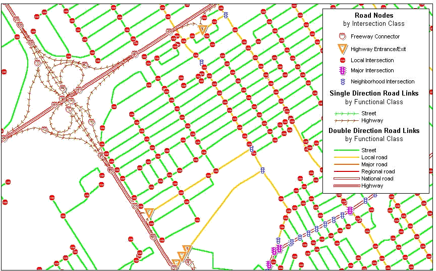
Figure 3 Location of the postal codes on the road map |
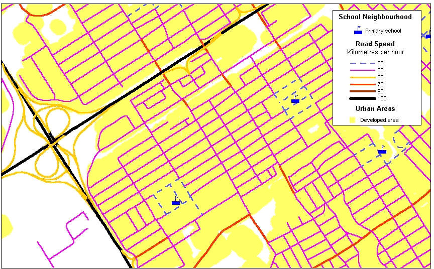
Figure 4 Assignment of maximum speed to every road link |
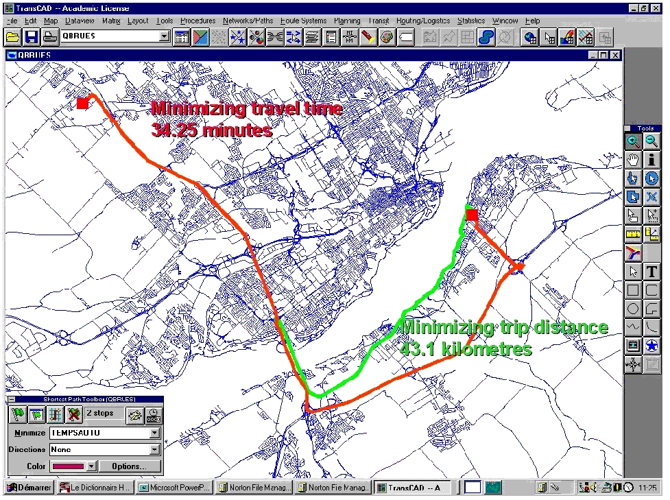
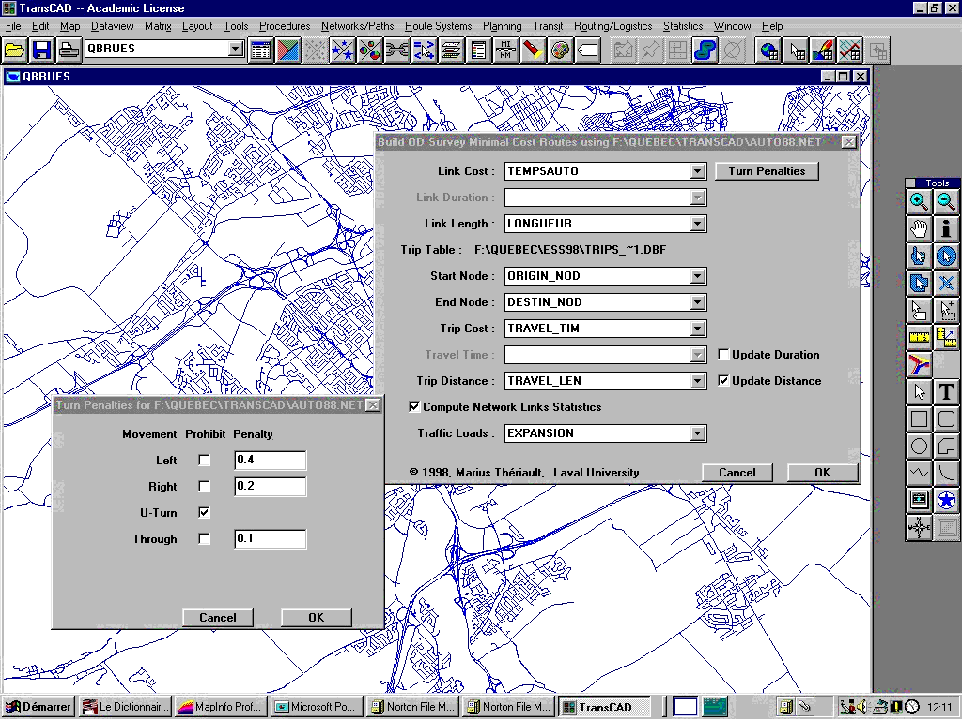
Figure 5 Finding optimal routes using TransCAD |
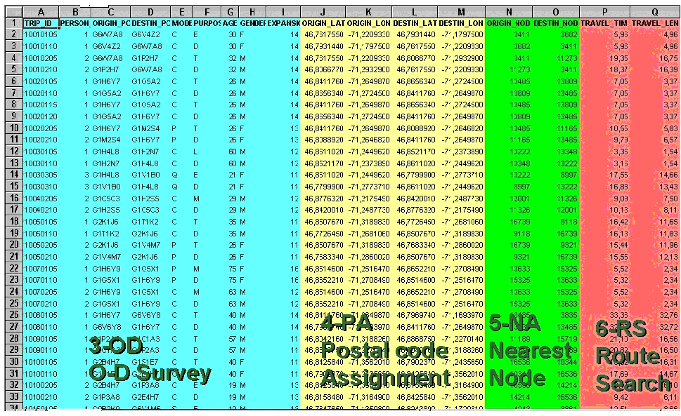
Figure 6 Adding trip location and statistics to an O-D survey table |
|
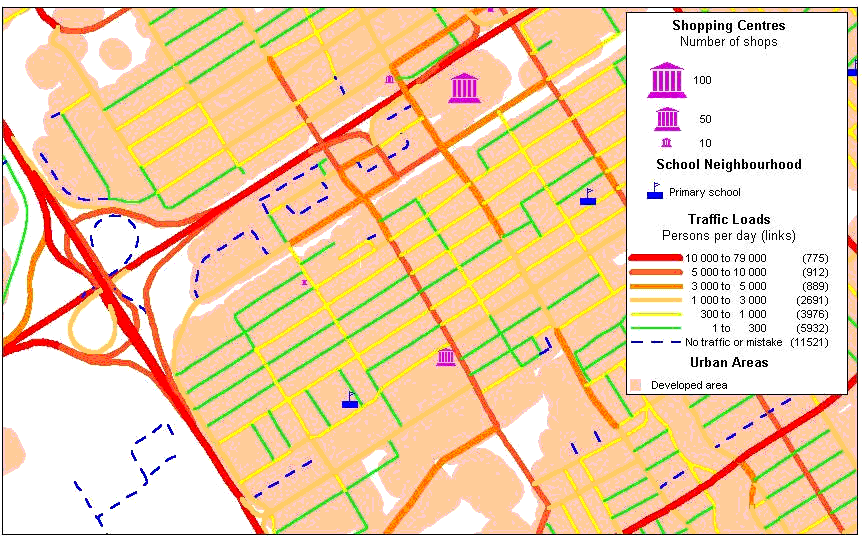
Figure 8 Estimated traffic during a typical weekday: Example for Limoilou, Fall of 1991 |
4.
Empirical results and discussion
The main purpose of this project being to develop a tool adapted for
small transportation agencies and low-funded research projects, it was
decided at the very beginning to retain a PC platform using a conjunction
of two low cost and widely available GIS packages, MapInfo and TransCAD,
running on the popular Windows 95 or Windows NT platforms. These two packages
are user-friendly and provide excellent interoperability features (ODBC,
SQL relational principles, MapInfo interchange format to handle map and
data transfers, extension through MapBasic and GISDK languages, etc.).
Beyond specific simulations
from our OD survey, the primary goal was to develop a procedure that can
be re-used for various other purposes, such as modelling the time accessibility
of services within a city, comparing the efficiency of two transportation
modes, etc. Processing times (based on a 200 MMX Pentium PC with 96 Megabytes
of RAM) are reported in Table 2, and can
be useful to estimate the feasibility on any specific project using that
procedure. While refining our approach, early processing time expectations,
expressed in days or weeks, became hours, and even, minutes. However, we
experienced some performance problems with the TransCAD route simulations.
After some 80,000 routes had been found at a very impressive speed, the
system performance gradually deteriorated showing excessive disk activity.
After 90% of the overall modelling task was carried out in about 12 hours,
activity reports displayed on the screen by our GISDK application indicated
that about 1% of the remaining task took the next 10 hours. So, we decided
to cancel the processing. The problem is probably related with overlays
and data transfer between the RAM and the virtual memory that appears when
the task is large and the available disk space becomes low. Thereafter,
we decided to disable virtual memory swapping at the system level and to
restart the application. The system performance then stay constant and
the reported time of 722 minutes for route simulations appearing in Table
2 comes from this operation. Using memory swapping yields longer processing
times, even for small tasks. TransCAD, as well as many other packages,
seems relatively unstable without virtual memory and it is highly advisable
to reset the system after the simulation results are secured to disk.
A second test was conducted
to model the same trips using a criteria set pertaining to travelling by
bicycle: 20 km per hour, highways prohibited, time penalties of 0.2 minute
for a left turn, 0.1 minute for a right turn, 0.4 minute for an U-turn,
and 0.2 minute for a through movement. Providing ample disk space, the
system performance was stable and the job took 1917 minutes of processing
time. Part of the increase in computing time (1917 / 722) is related to
greater complexity of each route; the number of links to pass through is
larger when one has to avoid highways. Most shortest path algorithms are
marginally sensitive to such increasing complexity.
The first three steps in
the modelling procedure imply fixed costs that must occur only once or
at specific times for a region (generally during census, at 5 years intervals).
That is where the higher investment burden is concentrated. In many regions,
including North America, these data are currently available and the investment
has already been made. The remaining three steps imply mainly operational
costs that are very low when compared with the investment in data gathering.
Furthermore, the added value of information is very high compared with
the marginal operational costs, clearly yielding benefits. Despite,
its pitfalls if the sample size is too small, transforming an OD survey
to estimate traffic at every point of a network is cost-effective when
compared to that of operating a vehicles count to monitor network
over an entire region. Furthermore, simulation results can be calibrated
using such real world measurements.
This simulation procedure
adds three important pieces of information to the OD trip table (travel
time and route length) and to the road network (traffic count). These supplemental
attributes may be associated with other pieces of information already in
these data sets to generate detailed analyses of commuters behaviour. Future
enhancements of our GISDK macro will enable the production of polylines
associated with the physical route followed by each traveller and their
export in a format compatible with GIS packages.
Analysing the situation
of the Quebec region in detail is far beyond the scope of this paper. The
procedure must be extended to include specific methodologies to model public
transit networks with schedules and transfer penalties before it becomes
fully appropriate to model all transportation modes. However, Table
4 and Figure 8 give some examples of the type of
information one may generate with subsequent statistical analysis and mapping
operations using these data.
Table
4 shows statistics based on aggregating travel time (minutes) and route
length (kilometres) of all OD 1991 trips segmented by gender of the travelling
person, trip purpose and transportation mode (car driver, car passenger
and taxi passenger). Individuals using the bus system, biking or walking
were excluded because the simulation criteria used are irrelevant to their
situation. Table 4 reveals
classical findings. Men do more trips to work than women mainly because
they are more involved in the labour market. The proportion of trips made
by women as car passengers (18%) is three times that of men. Men make longer
trips to their work place (Johnston-Anumonwo et
al. 1995; Blumen and Kellerman 1994). However, differences of travelled
distance between genders (9.84 km versus 8.94 km) are becoming smaller
than those of previous surveys. This could be an indication that travel
behaviour of men and women is becoming more similar (Camstra
1996). Trips for shopping by passengers (car or taxi), are mainly made
by women (84%), but the lengths of these trips are quite similar at 6.64
km and 6.36 km for women and men, respectively. Since OD data and road
network are located in space, it is also possible to aggregate results
by geographical areas such as municipalities, zones or census tracts. Then,
aggregating trips in order to compare downtown and suburb locations would
probably be useful to analyse differences between men and women in terms
of trip length or home location decision (Preston
and McLafferty 1997). Figure 8 presents a zoom
over a map of traffic density (persons travelling on each road segment).
In MapInfo and TransCAD, this coverage can be related to other geographical
phenomena; for example, road accidents weighted by traffic density, residential
and commercial property values, or the impacts of traffic noise. We are
conscious that our road network still contains some errors, but the model
allows these to be rapidly identified.
Computed
with SPSS using GLM General factorial and OD survey Expansion factorOverall,
the computing speed of TransCAD to carry out route simulation was impressive
and beyond expectations. However, even after personal communication with
Caliper's staff, it was impossible to obtain details about the type of
algorithms used in their package. The results look credible but we cannot
verify their relevance using scientific criteria. The GISDK language is
very powerful and efficient, but our programming task was jeopardised by
many mistakes in the programmer's guides. We even had to guess the exact
syntax and results format of some commands used in our application, due
to poor and confusing documentation and examples. The procedure needs moderate
hardware and software investment (< 15,000 US$). Personnel training
is mandatory, but short, since all software packages (e.g. MapInfo and
TransCAD) are user-friendly.
5. Conclusion
The preceding paragraphs illustrate clearly the usefulness of including
both time and distance in studies of urban travel (Makin
et al. 1997). Indeed, the traditional uses of OD surveys substantially
under-use the richness and variety of data they contain. Preliminary results
indicate that it is possible to combine GIS and transportation modelling
to estimate travel time of urban commuters. This could help measuring temporal
constraints of households planning their daily activities (Arentze
et al. 1993; Miller 1991). It should also enhance OD surveys
in order to improve analysis of urban dynamics.
The strategy used to simulate
commuters trips in the Quebec metropolitan area illustrates the benefits
of extending the capacity of existing GIS providing efficient and task
oriented simulation procedures using full integration (one software) or
tight coupling strategies (interoperability). The demand for a comprehensive
and behaviour-compatible route simulation system in transportation industry
is tremendous. Applications include the comparison of various public transportation
routes between two points, a better evaluation of demand for transportation
resulting in closely adapted services, and the optimisation (yet to be
defined) of public transportation journeys, to mention only a few. With
such systems, the comparison of travel time between car and public transportation
on a large scale will be possible by aggregating of individual trips characterised
by the socio-economic attributes of commuters though to influence their
likely behaviour (modal choice, elasticity of time cost, family style,
etc.).
The procedure presented
here admittedly suffers from some limitations, among others the fact that
the route actually selected may be only one among the likeliest, but not
necessarily the shortest one (Gopal and Smith 1990).
Ideally the modelled route should be the most probable, at least one of
the more likely, considering travel time. Moreover, it is clear that people
moving around do not always follow the shortest route (time-wise or distance-wise)
but rather travel with due regard to other considerations (Hanson
and Huff 1988) such as security, landscape and environmental quality,
or stops related to family life (kindergarten, school, grocery store, etc.).
Nevertheless, the shortest
path hypothesis is probably among the best that can be used to exploit
data coming from OD surveys, at least in their current state. Transportation
simulation could also be improved upon by direct observation of vehicles
equipped with GPS or the use of interviews and travel diaries (Lee-Gosselin
1996; Doherty and Miller 1997; Ben-Akiva and Bowman 1995). However,
the overall costs would be so high that it seems reasonable to apply such
methods to small, high-quality samples from which behavioural mechanisms
can be better understood and the assumptions in behavioural models modified
accordingly. Meanwhile, under present economic conditions and technologies,
it appears more reasonable to rely primarily on route simulations to improve
our understanding of population mobility and transportation planning at
the scale of urban regions.
Trip duration generated
with this procedure will be used for other methodological or applied research.
It will enable:
Arentze, T., A. Borgers and H. Timmermans (1993) "A Model of Multi-purpose Trip Behavior." Papers in Regional Science 72(3): 239-256.
Ben-Akiva, M. E. and J. L. Bowman (1995) "Activity-based Disaggregate Travel Demand Model System with Daily Activity Schedules." In Conference on Activity-Based Approaches: Activity Scheduling and the Analysis of Activity Patterns, Eindhoven, The Netherlands.
Blumen, O. and A. Kellerman (1990) "Gender Differences in Commuting Distance, Residence, and Employment Location: Metropolitan Haifa 1972 and 1983." Professional Geographer, 42(1): 54-71.
Caliper Corporation (1996) TransCAD: Transportation GIS Software Reference Manual, Version 3.0, Newton, MA.
Camstra, R. (1996) Commuting and Gender in a Lifestyle Perspective. Urban Studies, 33(2), 283-300.
Claramunt, C. and M. Thériault (1996) "Toward Semantics for Modelling Spatio-temporal Processes within GIS." In Advances in GIS Research II, M.J. Kraak and M. Molenaar Eds., London, Taylor & Francis, 27-43.
Claramunt, C., M. Thériault and C. Parent (1998) "A Qualitative Representation of Evolving Spatial Entities in Two-dimensional Topological Spaces." In Innovations in GIS 5, S. Carver Ed., London, Taylor & Francis, 128-138.
Des Rosiers, F., A. Lagana, M. Thériault and M. Beaudoin (1996) "Shopping Centers and House Values: An Empirical Investigation." Journal of Property Valuation and Investment. 14(4): 41-62.
Doherty, S. T. and E. J. Miller (1997) "Tracing the Household Activity Scheduling Process using one-Week Computer-Based Survey." In Proceedings of the Eighth Meeting of the International Association of Travel Behaviour Research, Austin, TX.
England, K.V. L. (1993) "Suburban Pink Collar Ghettos: The Spatial Entrapment of Women." Annals of the Association of American Geographers, 83(2): 225-242.
Etches, A., C. Claramunt, A. Bargiela and I. Kosonen 1998. "An Integrated Temporal GIS for Model Traffic Systems." GIS Research UK VI National Conference, University of Edinburgh, UK.
Gärling, T. and E. Gärling (1988) "Distance Minimization in Downtown Pedestrian Shopping Behavior." Environment and Planning A 20: 547-554.
Golledge, R. G., M.-P. Kwan and T. Gärling (1994) "Computational Process Modeling of Household Travel Decisions using a Geographical Information System." Papers in Regional Science, 73(2): 99-117.
Gopal, S. and T. R. Smith (1990) "Human Way-finding in an Urban Environment: A Performance Analysis of a Computational Process Model." Environment and Planning A 22: 169-191.
Gordon, P., H. W. Richardson and M.-J. Jun (1991) "The Commuting Paradox Evidence from the Top Twenty." Journal of the American Planning Association, 57(4): 416-420.
Hanson, S. and J. Huff (1988) "Systematic Variability in Repetitious Travel." Transportation 15: 111-135.
Hanson, S. (1995) The geography of Urban Transportation (Second Edition). New-York: The Guilford Press.
Johnston-Anumonwo, I., S. McLafferty and V. Preston. (1995) Gender, Race and the Spatial Context of Women’s Employment. In Gender in Urban Research, edited by J. A. Garber and R. S. Turner, Urban Affairs Annual Review 42. Sage Publications, pp. 236-255.
Khoong, C. (1993) "Shortest-Path Reconstruction Algorithms." The Computer Journal, 36(6): 588-592.
Korem (1998) MapLogix Version 2.0. Topological Map Editing Utility for MapInfo Professional. Http://www.korem.com/maplogix/index.html.
Lee-Gosselin, M. E. H. (1996) "Scope and Potential of Interactive Stated Response Data Collection Methods." In Household Travel Surveys: New Concepts and Research Needs, Conference Proceedings, Transportation Research Board, National Research Council, Washington, DC.
Makin, J., R. G. Healey and S. Dowers (1997) "Simulation Modelling with Object-Oriented GIS: A Prototype Application to the Time Geography of Shopping Behaviour." Geographical Systems 4(4): 397-430.
MapInfo Corporation (1996) MapInfo Professional Reference and User's Guide, Troy, NY.
Miller, H. (1991) "Modelling Accessibility using Space-time Prism Concepts Within Geographical Information Systems." International Journal of Geographical Information Systems, 5: 287-301.
Pearn, W., L. Lea and L. Mao (1994) "Algorithms for the Windy Postman Problem." Computers & Operations Research, 21(6): 641-651
Preston, V. and S. McLafferty (1993) Gender Differences in Commuting at Suburban and Central Locations. Revue canadienne des sciences régionales, 16(2), 237-259.
Sedgewick, R. (1990) Algorithms in C. Addison-Wesley Publishing, United-States, 657 pages.
Thériault, M., P. Lemieux, R. Sirois and P. Villeneuve (1995) Géobase du réseau routier public de la région de Québec. Format Mapinfo 3.0, CRAD, Laval University, Québec.
Thomas, C., M. Beaudoin and M. Thériault (1996) "Méthodologies de localisation et de classification socio-professionnelle: le cas de l'enquête O-D 1991 de la STCUQ." Cahiers de Géographie du Québec, 40(109): 69-90.
Villeneuve, P. and D. Rose (1988) "Gender and Separation of Employment from Home in Metropolitan Montreal, 1971-1981." Urban Geography, 9: 155-179.