
David Pullar
Geographical Sciences and Planning,
The University of Queensland, Brisbane, Australia. Q4072
D.Pullar@mailbox.uq.edu.au
| Contents
1. Introduction 2. GIS And Multiple Criteria Evaluation 3. Integrating Spatial Interaction Models and GIS 4. Solution 5. Case Study 6. Conclusion References |
ABSTRACT
Multiple criteria evaluation is a structured
process to define objectives, to formulate criteria and to evaluate solutions
in a decision problem. Relatively straight-forward procedures may be applied
to perform land use evaluation within predefined land regions as long as
there are no complex interactions across these spatial units. Interactions
may occur because of flows or influences between neighboring regions. While
there exists a large body of literature to model these geographical interactions,
there are relatively few attempts to link this into the decision-making
process. This paper describes a methodology to include spatial interactions,
modeled as constraints for land allocations, into multiple criteria evaluation.
The paper reviews tools, techniques and models for land use allocation.
A solution is presented where an allocation model is coupled to multiple
criteria evaluation. This is then applied to a forest resource application
as a case study.
KEYWORDS:geographical information systems, spatial constraint, allocation model, resource assessment. |
2.
GIS And Multiple Criteria Evaluation
A geographical information system (GIS) provides the processing capability
to assess spatial criteria as part of a multiple criteria evaluation (MCE)
procedure (Carver, 1991). The benefit of using a GIS is that constraints
can be based upon spatially related data, such as distance to a road, and
the GIS is a suitable computing tool to perform the MCE analysis (Jankowski,
1995). The most prevalent procedure for integrating MCE and GIS for
land suitability analysis is using a linear weighted combination (LWC)
approach (Eastman et al., 1995). In this
approach land information is transformed to a set of factors over the study
area. These factors are combined by applying a weight to each factor, followed
by an overlay summation to yield a suitability map. This map can be used
directly for satisfying a single objective, or a multiple objective analysis
procedure applied to allocate areas according to the highest ranked objective.
It has proven to be a very popular technique because it can readily include
judgements from decision-makers (as factors or weights) to influence the
outcome.
The suitability score S is computed as:
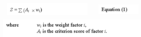
The logic that lies behind
multiple criteria evaluation is to compute a combined suitability score
for each location, and then rank the most suitable locations to arrive
at the best solution. This is illustrated in Figure 1a.
A set of standardised factors Ai and their respective
weights wi are combined by additive computation to produce
a suitability map S. In most applications there is an additional
step to identify the best sites R using a decision rule based upon
a heuristic choice, typically this is done by priority ranking the values
in S and allocating the best number of sites. An example would be
identifying the best amenity areas in a forest as a combination of factors
for proximity to walking tracks and streams, moderate relief, and away
from conflicting land uses such as logging. These factors can be computed
using a cartographic model (Tomlin, 1991). Once
a combined suitability score is obtained by equation (1),
then a specified number of hectares are chosen from the highest ranked
values for further investigation as amenity land uses.
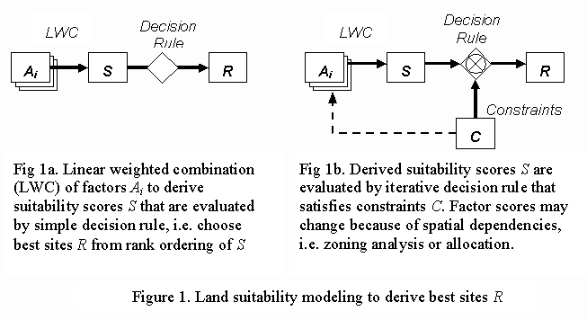
3.
Integrating Spatial Interaction Models and GIS
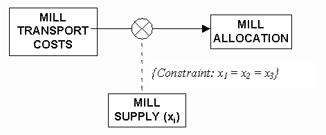
Location-allocation models provide a set of techniques to explicitly
handle flow relationships between spatial phenomena (Fotheringham
and O'Kelly, 1989). These models incorporate spatial interactions as
flows between and from locations. They are used commonly in business geographics
to model market catchment, or flows between supply and demand regions.
They are based upon central place theory, that is they model the flow between
central facilities (supply) and a set of distributed zones (demand). Conceptually
a measure of supply-demand interaction can be described in terms of gravitational
attraction. The model of interaction between two spatial entities is as
follows:
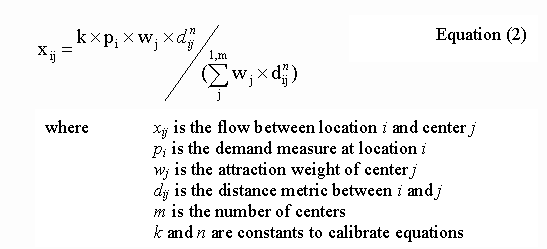
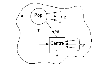
Figure 2 shows the relationship schematically for a retail shopping center. It assumes that shoppers choose a center in direct proportion to its attractiveness (amount of floorspace) and in inverse proportion to the distance between the origin i and each competing center j. There are many variations upon the basic interaction model to deal with contributing factors such as competition, attractiveness, and travel costs. More advanced models also deal with hierarchies of centers (Roy and Anderson, 1988).
 |
|
|
An advantage of allocation
models is that they explicitly deal with interactions, namely by using
a set of heuristic rules and a distance metric to model which resources
flow to designated centers. Allocation models are part of a large class
of mathematical programming techniques, which focus on constrained optimisation
methods to find the solution to functional relationships. These techniques
are extremely popular in management science and have been applied to GIS,
but they have certain limitations (Chuvieco, 1993;
Arthur and Nalle, 1997). For instance, functional relationships need
to be evaluated over continuous scalar value domains. In resource management
we often deal with categorical values and a variety of evaluation methods
including nonlinear and logical relationships. In addition, many aggregate
summary values such as zonal or neighborhood operations are difficult to
incorporate in a mathematical programming solution.
The next section will present
a methodology to combine a linear combination model and an allocation model.
While the solution is not generic at this stage, it could be extended to
include a broad set of interactions and spatial distribution models. The
methodology is demonstrated in the context of a forestry application.
4.
Solution
This section presents a solution to the problem of coupling an allocation
model with multiple criteria evaluation. Allocations are expressed as constraints,
which are satisfied as part of the decision evaluation. The principle is
shown in figure 1b. A model is developed using a LWC procedure to determine
suitability scores S from the decision factors Ai.
This suitability map is computed as part of a cartographic model. An allocation
model is then run to determine which areas satisfy one or more constraints
C.
The suitability scores represent the preferred locations for use as the
demand. A modified distance metric is used to help determine the closest
supply points to service this demand. The interaction model serves to evaluate
this demand-supply constraint. A solution using an iterative approach is
suggested. An initial result is computed by allocating the most suitable
areas to their nearest center. This also requires satisfying a constraint
on the total amount of demand, or the total amount of the resource, that
may be utilised. This gives a computed allocation ![]() for the accumulated demands that are assigned to each center. This allocation
is then checked against a constraint for the desired allocation
for the accumulated demands that are assigned to each center. This allocation
is then checked against a constraint for the desired allocation ![]() .
For instance, we may wish to evenly distribute the allocation between centers.
Adjustments are then made to the weights in the interaction model to satisfy
the desired allocations. Because of spatial dependencies in the criteria
scores, i.e. due to zonal aggregations or the way proximity measures are
computed, this causes slight changes in the suitability map. Hence the
evaluation is repeated in an iterative fashion until there are no significant
adjustments to be made. The result R reflects the most suitable
sites that satisfy the constraint allocation. Adjustments are computed
as:
.
For instance, we may wish to evenly distribute the allocation between centers.
Adjustments are then made to the weights in the interaction model to satisfy
the desired allocations. Because of spatial dependencies in the criteria
scores, i.e. due to zonal aggregations or the way proximity measures are
computed, this causes slight changes in the suitability map. Hence the
evaluation is repeated in an iterative fashion until there are no significant
adjustments to be made. The result R reflects the most suitable
sites that satisfy the constraint allocation. Adjustments are computed
as:
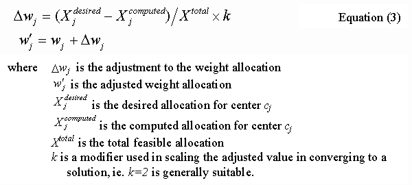
Step 2. Compute an allocation for sites using Equation (2)
and accumulate these to give the allocations at each center ![]()
Step 3. Test resulting allocation against the constraint for desired
allocation ![]() and
compute adjusted weight values using Equation (3)
and
compute adjusted weight values using Equation (3)
Step 4. If
Dwj changes significantly
then:
The technique is demonstrated with a forest management case study. Management of forest resources involves considering many economic and environmental factors. The factors include not only cost effective and sustainable production, but also conservation and preservation of environmental habitats. Determining the best sites for timber harvesting is a problem that suits both multiple criteria evaluation and spatial modeling. Multiple criteria evaluation is used for decision analysis, and spatial modeling is used to compute costs for moving logs and their allocation to mills for sawing. Figure 3 shows a high level model of the problem. Forests are managed as discrete spatial units that represent the smallest area for making a decision. There are three mills in the region and it is highly desirable to allocate the workload evenly among these mills. The process of deciding the best sites for harvesting and preservation include evaluating the following:
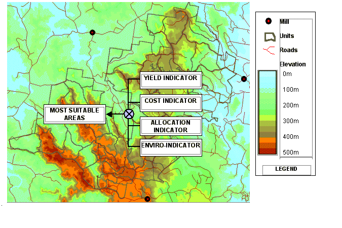
| Figure 3: Forest study area and indicative factors used to evaluate areas for harvesting. |
A cartographic model was
used for the computation of factors and indicators (McKendry
et
al., 1995). While these criteria and the subsequent factor development
represent only a subset of what would be considered in a complete application,
one can appreciate the amount of logical and computational modeling that
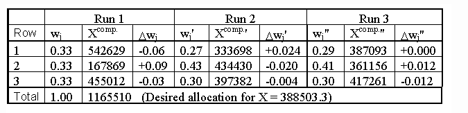
takes place. The main aspect of the model we will focus on is the allocation
for the mill. This is shown in Figure 4.
 |
|
|
Table 1: Iterative evaluation
of constraint and subsequent adjustment of interaction model
weights to satisfy constraint to evenly allocate resource
to each mill.
6.
Conclusion
The advantage of linear combination is its simplicity and flexibility
to include spatial modeling in a multiple criteria evaluation. However
it is still an essentially point-based evaluation method. That is, it computes
a score at each location and as a post-procedure it priority ranks the
highest valued locations to make up a prerequisite total land area. Linear
combination is unable to accommodate constraints that involve spatial relationships
and dependencies. For instance, a constraint to evenly allocate land resources
to a set of target distribution centers. These problems are normally handled
by mathematical programming solutions. But it would be desirable to include
such constraints in the linear combination method. Two significant classes
of spatial dependencies are desirable: 1) space allocation models, and
2) spatial distributions. Spatial constraints of this nature can be solved
using a sub-optimal procedure that iteratively evaluates the models against
a constraint until a stable balance is achieved.
The paper describes a method
to include spatial constraints for a resource allocation problem. The process
is applied to a relatively complex case study for balancing production
and environmental interests in managing commercial forests. The objective
of production is to get the maximum timber yield from the forest in the
most cost effective manner. Regulations control some environmental aspects
of what can be harvested, e.g. terrain slopes, old growth habitat and hydrology.
Costs relate to harvesting and transporting logs to the closest mill. Utilisation
of the mills is also important so the milling workload must be approximately
distributed evenly to several mill locations. The MCE analysis evaluates
a cartographic model to determine suitable areas for logging, and then
selects areas that satisfy a constraint to evenly allocate the resource
to a number of mills.
References
Arthur J.L. and Nalle D.J. (1997) Clarification of the Use of
Linear Programming and GIS For Land-Use Modelling, International Journal
of Geographical Information Systems, 11(4), 397-402.
Bailey T.C. and Gatrell A.C. (1995) Interactive Spatial Data Analysis, Longmann Scientific & Technical, Essex.
Brookes C.J. (1997) A Parameterized Region-Growing Programme for Site Allocation on Raster Suitability Maps. International Journal of Geographical Information Systems, 11(4), 375-396.
Carver S.J. (1991) Integrating Multi-Criteria Evaluation with Geographic Information Systems, International Journal of Geographical Information Systems, 5(3), 321-339.
Chuvieco E. (1993) Integration of Linear Programming and GIS for Land-Use Modelling. International Journal of Geographical Information Systems, 7(1), 71-83.
Eastman J.R., Jin W., Kyem A.K. and Toledano J. (1995) Raster Procedures for Multi-Criteria / Multi-Objective Decisions. Photogrammetric Engineering & Remote Sensing 61(5), 539-547.
Fotheringham A.S. and O'Kelly M.E. (1989) Spatial Interaction Models : Formulations and Applications, Kluwer Academic Publishers, Dordrecht, Holland.
Jankowski P. (1995). Integrating Geographical Information Systems and Multiple Criteria Decision-Making Methods. International Journal of Geographical Information Systems, 9(3), 251-273.
McKendry J.E., Eastman J.R., St. Martin K. and Fulk M.A. (1995) Explorations in Geographical Information Systems Technology, UNEP/UNITAR, Clark University, Worchester.
Roy J.R. and Anderson M. (1988) Assessing Impacts of Retail Development and Redevelopment, In: P. Newton, et al., Desktop Planning, Hargreen Publishers, Melbourne.
Tomlin C.D. (1991) Cartographic Modelling, In: D. Macguire, M
Goodchild and D. Rhind, Longman (eds) Geographical Information Systems,
1, 361-374.