Section I: Short Answers
Answer 1 out of the 2 following questions. Each is worth 10 points.
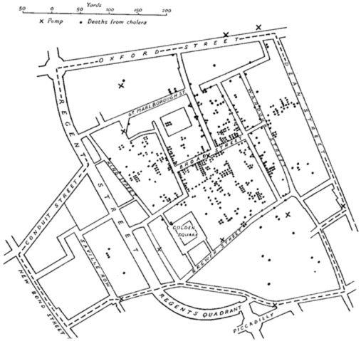
1. Graphic Interpretation Question: The problem of identifying which well is contaminated in the (well known...) map below could be approached by a contemporary MD using cartographic modeling. It is suggested that the following MFworks operation would be central to the procedure:
SaveSouls = Scan DEATHS-FROM-CHOLERA Within 7 Density Around WELLS
Explain what the Scan function does with reference to the given modifiersWithin , Density and Around . In your explanation, specifically refer to what each word and number in the operation statement indicates.
2. Nimble Recode: Recode the input map whose legend has {Void, 0, 1, 2, 3} so that the output map has {Void, 0, 2, 3} using a single Assigning clause.
Section II: Modeling
Answer 2 out of the 4 following questions. Each question is worth 20 points.
3. In Assignment No. 5, Part III "Visualizing the RS Extracted Theme (Vegetation)" it was stated: "And now for a more involved visualization product: we will visualize Greenery using a rendering technique similar to that used in theTopoLandscape layer (TopSpot database). In effect this means implementing translucent overlay which provides a neat "see through" effect while retaining more information, as compared to an ‘obliterating Cover’." How does the translucent overlay technique work? Accompany your explanation with a script.
4. Equation Calculation and Explanation:
The following filter works like an LPF except that it uses the following weights:
| 0 | -1 | 0 |
| -1 | 9 | -1 |
| 0 | -1 | 0 |
Calculate the results this filter will yield for the following 24 bolded cells in a 8x6 input map patch:
|
|
|
|
|
|
|
|
|
|
|
|
|
|
|
|
|
|
|
|
|
|
|
|
|
|
|
|
|
|
|
|
|
|
|
|
|
|
|
|
|
|
|
|
|
|
|
|
|
|
|
|
|
|
|
|
Provide your calculations in a 6x4 output map patch.
What does this filter do?
5 Provide a solution to the Road Network Proximal Inheritance Problem. This problem concerns itself with efficient ways to have adjacent cells inherit the exact same values as their neighbours. Think of a road network map where each road is one cell thick and has a unique value (that is different for each road). How can we have the neighboring cells on each side of the road "inherit" that same value? This problem can be licked with as little as a 5-line script.
6. another choice problem....
Section III: Mini Essay – From "Getting Started with G.I.S."
Write an organised, neat, and doublespaced 3 page mini essay on 1 of the following 3 topics. Focus on the main points. First make and include a rough outline, and then provide your mini essay. Write simple accurate sentences. Use a pen. The mini essay is worth 20 points.
7. Essay Title: "Statistical Analysis". [This section appears in Chapter 6: Whi Is It There?].
8. Essay Title: "Data Capture". [This sub-section appears in Chapter 8: How To Pick a GIS, under the GIS Software Capabilities section].
9. Essay Title: "The Future of GIS" [Chapter 10].
Section IV: Short Essay – Primarily from the Lecture Notes
Write a well organised/stuctured 5 page doublespaced short essay on 1 of the following 2 topics. First make an outline, and then write your short essay. Submit neat final versions of both your outline and your short essay. Include examples and diagrams if relevant. Write simple accurate sentences. Use a pen. The short essay is worth 30 points.
10. The User-Oriented Taxonomy of Spatial Image Processing Operations.
11. MFworks Group II: Basic operations on 1 to n layers.